ENHG Field Trip: Fossil Valley
ENHG Field Trip: Fossil Valley - 19th/20th February, 1980
Following the successful field-trip along the Sueyhan Road on 9th January (Bulletin 13, p. 7 ) it was decided to take advantage of the continuing cool weather and plan a mini- expedition to the Al Ain area. The location chosen was Jebel Huwayah, popularly known as "Fossil Valley". Though technically in Oman, the region may be reached easily by saloon cars and the flora and fauna is not intrinsically different from that of the foothills that straddle the border.
Seven members camped overnight at the SW end of the valley under a full moon. The night was windless and the temperature was warm and there was no dawn mist. The following morning a further dozen vehicles turned up and groups of people visited different parts of the locality according to their interest. Most people were attracted by the abundance of marine fossils to be found along the inner slopes of the 'horseshoe' rim.
I Geography and GeologyDuring early Permian times shallow seas transgressed across the eastern margin of the Arabian continent and a series of marine shelf carbonates was developed on a basement complex of pre-Permian sedimentary, igneous and metamorphic rocks. Sedimentation and reef-building continued through Permian to mid-Cretaceous times (135 -90 million years) but the whole region had stabilized by the Maestrichtian era. Some shallow water sedimentation took place until the Miocene, which witnessed the final uplift and folding of the Hajar Mountains in Oman. In the western foothills, e.g. in the Al Ain vicinity, simple open folds developed and these were a major contribution to the present visual aspect of the region.
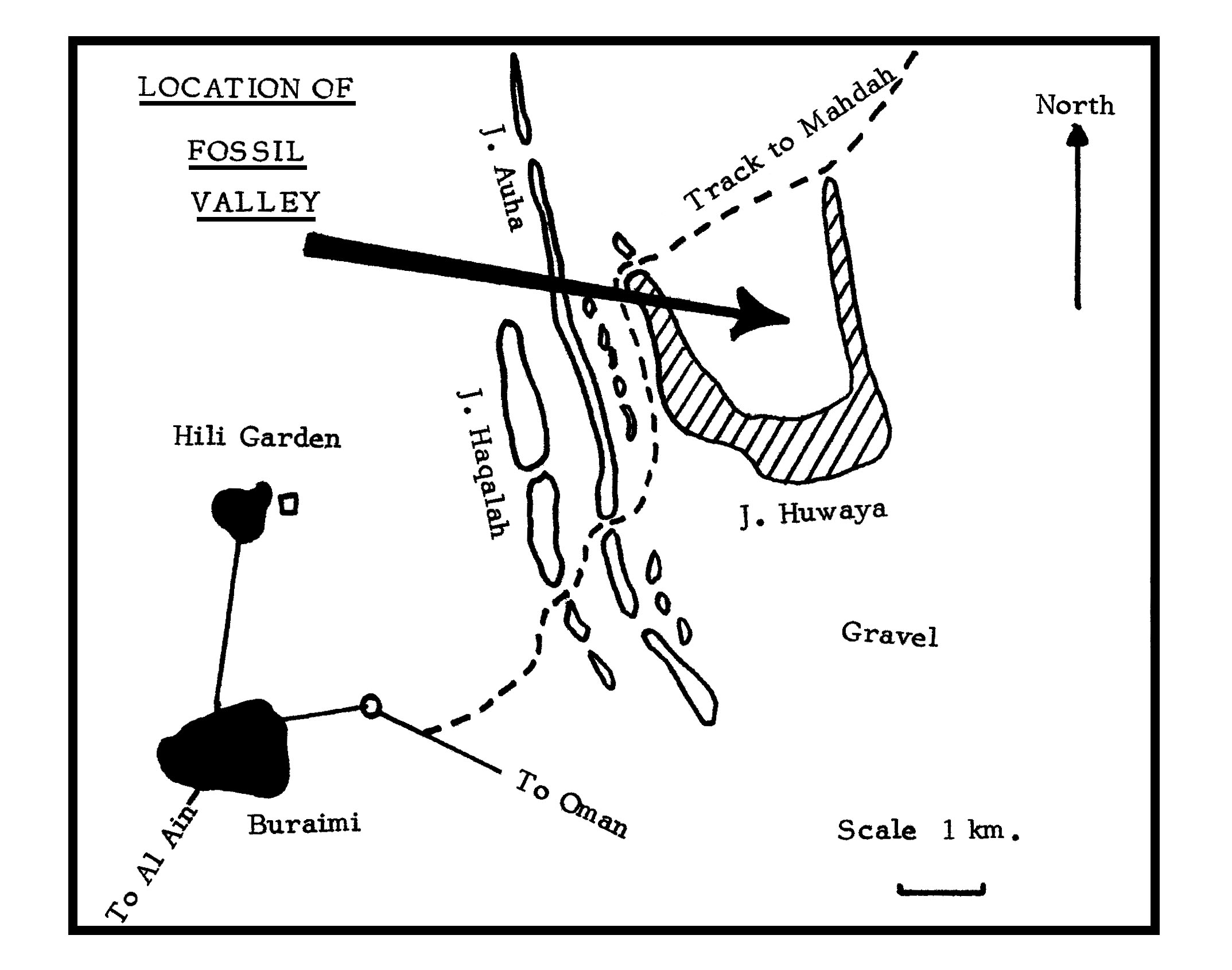
Jebel Huwayah is a NNW-SSE trending anticline that has been eroded through dissection of the escarpment by small wadis. The only surface feature to indicate the former presence is the curved ridge-line of upper Maestrichtian limestones, which form the limbs of the fold. The wadis have cut back into the updip side (the beds dip at a low angle to the S) to produce the central basin. The low gradient escarpment top was probably less easily eroded and the wadis, though somewhat incised, are meandering and long. Those in the centre of the horseshoe have now de- graded into runnels, scree and gravel slopes forming a narrow pediment fan. The saw-tooth outline of the jebel is caused by simultaneous erosion of the feature by wadis from both sides.
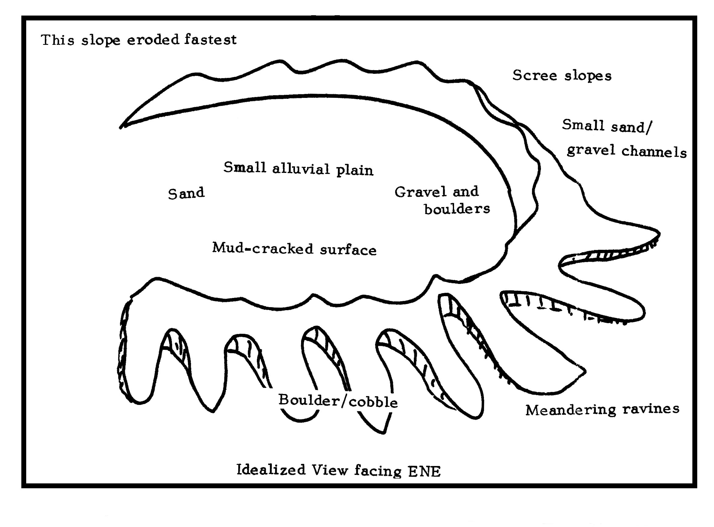
From the steep inner slope small channels (best seen from above) run part of the way into the basin centre, reflecting the course of periodic channelized runoff. Grain size decreases from boulders and cobbles at the foot of the cliff to sand and fine gravel grade out in the basin centre, which is a rudimentary playa. Wind-blown sand has almost covered some slopes, particularly along the eastern inner rim; sand-blasted and polished rocks and pebbles are common, even locally at the cliff top where affected by strong winds. Limestone boulders which litter the escarpment surface reflect the slow rate of erosion there. These rocks have been eroded through a combination of weathering and drainage patterns. The distinctive upper surfaces display minute "clints" and "grikes" while the lower surfaces exhibit tiny stalactites or white lime coating reflecting redeposition of carbonate material dissolved from the top surface by rare incidences of rainfall. Diurnal temperature changes have contributed to rock shattering and possibly represent the chief means of production of the boulders and cobbles.
The sedimentary deposits of the jebel consist of carbonaceous shelf limestones which overlie a conglomerate of undetermined age. Many of the pebbles and rocks in this conglomerate consist of vein quartz and chert. Much of this is red-stained and is a form of poor quality jasper. There is irregular contact between the limestone and the conglomerate.
The limestones are highly fossiliferous, containing a diverse fauna of Hippuritid rudists, gastropods, small bivalves and corals of several varieties. The rudists, like long curved horns in appearance (though mostly broken) are large bivalves all of one variety, up to 35cms. in length. They occur predominantly in a narrow horizon a little above the conglomerate. Corals persist higher up, though the higher rocks are heavily weathered. Most of these fossils were laid down in the Cretaceous (up to 65 million years ago).
A large variety of fossils was collected by individuals during the trip. The largest rudists found were up to 25cms. long and l5cms. diameter across the blunt end. None were complete specimens. Molluscs included shapes and sizes familiar to present-day Gulf beachcombers.
II Archaeology and HistoryLittle is known in detail of the recent history of the immediate Jebel Huwayah locality beyond what is reflected in the records of surrounding oases. Mahdah, to the NE has long been a centre of local importance with its fresh springs and 'aflaj' or water channels. Buraimi, to the W, is the provincial capital of this part of Oman and its history is closely tied to that of Al Ain and other adjoining oases. The old souk in Buraimi with its mud-brick walls and barasti partitions, was replaced by the present modern showpiece at the end of 1979.
Presumably 'Fossil Valley' has been used for centuries as a winter-cum-spring grazing area, and it is still occupied annually after rains by family groups who move in complete with tents, sheets of corrugated tin, cooking utensils and of course the Datsun pickup, along with herds of camel and goat. On the occasion of the field-trip the valley was completely devoid of habitation and there was certainly no evidence of fresh grass or recent rains.
The Jebel was exploited in much earlier times, however. Along the top of the W rim there is a vein of chert, up to three metres broad which runs along the jebel for about a kilometre and a half. Worked flint implements, flakes and scrap are commonplace. Some of the flint is local, some of the flakes are from imported nodules, of unknown origin. The material has been described as "post-Neolithic" (Copeland, 1976) a loose term which in this margin of Arabia covers the period between 10,000 and 2,500 BC, i.e. up to the time of the local Bronze Age and perhaps locally beyond.
The S end of this vein was inspected during the trip and a few typical slug-shapes recorded. There was a high proportion of flakes bearing percussion bulbs and scars, evidence of human working, and many discarded flakes bearing cortex. No other traces of human activity have ever been recorded on top of this W rim apart from the evidence of two robbed cairns further N. These cairns mayor may not be contemporary with the flint-knappers. No settlement site has been discovered to date, if one ever existed.
There is no doubt that during the local Bronze Age (c.3000 - 1800 BC) the whole of the area surrounding Hili must have shared in the prosperity of the times. The present graded track which runs across the mouth of the horseshoe could easily have been one of the routes by which copper ore was transported from the Wadi Jizzi to Hili and the smelting kilns.
Any evidence of occupation of the basin would lie beneath deep alluvial deposits and require deep trenching to reveal archaeological remains. It is possible that a systematic survey of Jebel Huwaya, including aerial photography, could reveal ancient traces.
III ClimateThe Al Ain meteorological enclosure is situated at Lat. 25° 13' N and Long. 55° 47' E at a height of 302 metres, and the following brief resume is furnished from data collected between 1971-76.
Mean daily maximum temperatures rise from 23°C for January through 43.6°C for July and back to 24.9°C for December. The absolute maximum recorded in 1976 was in July (48.0°C). The mean for February, the month of the field-trip, is 24.2°C.
Mean daily minimum temperatures range from 9.2°C for January to 27.4'C for August, with an absolute minimum of 4.0°C being recorded for February 1976. The temperature during the night of the field-trip did not drop below 12°C.
Mean daily humidity in the area is highest in January at 61%, closely followed by December, 60%, and February 58%. The lowest is for October, at 38%. Rainfall averages 21.0mm. and 34.8mm. for February and March respectively, and these two months account for over half the average annual total. The region is noted for its summer storms between August and October, but these can be very-localized. At the time of the field-trip there was no evidence of recent rain.
Mean daily wind speed throughout the year averages 6 knots, only February averaging out higher at 7 knots. However, the breeze during the trip was below this level even at escarpment height. Evaporation is low in February, the mean daily rate being 6.7mm. against a monthly average throughout the year of almost 10mm. April to September is the period noted for high evaporation rates.
IV FloraAlthough individual members of the ENHG have made trips to the locality on several occasions in recent years, no survey of the valley's flora has ever been undertaken to our knowledge. Group members had briefly looked at the vegetation of lower Hafit in December 1980 and that was found to contain some specialized plants due to its sheltered and steeper environment. Such plants were not to be expected in Huwayah.
On arrival the valley looked in a fairly dessicated state. There was no young grass on the sandy mud-pans around the Acacia and Prosopis stands beneath the W rim, but there was evidence that many varieties of annual had flowered and died. These were now unidentifiable. There had been storms in the Al Ain area in the late summer and autumn of 1980 but apparently nothing in the Huwayah locality since the turn of the year. In late March 1978 there was a good covering of young grass around the trees, reflecting the incidence of rain in the late winter and early spring of that year. There is usually some rainfall in February but 1980-81 was a particularly dry winter season.
The acacias turned out to be all A. tortolis on the evidence of the small twisted legumes beneath and occasionally still attached to upper branches. Some still held seeds. At the SW end of the valley these were mainly dwarf trees up to 3 metres in height, but taller trees were in clumps further along the valley sides both E and W. All trees were heavily grazed up to camel height, and extremely thorny.
Although the camp-site was a good two hundred metres out on the plain, one or two Euphorbia larica bushes, easily identified by their cluster of thin green linear branches rising from a central base root complex, grew in the immediate vicinity. These plants are common on rocky hillsides throughout the region but not often found in valley bottoms. No plants were in flower, but some were in late fruit. The species has been recorded in flower in October (Masafi area) and in January (near Hatta). E. larica grows to 2 metres where favourable conditions exist.
Between the camp-site and the SW edge of the basin little curled-up 'balls' of Anastatica hierochuntica were much in evidence. After flowering, the leaf twigs harden and enclose the seeds tightly, while the leaves die off, and the plant waits in a dormant state until there is sufficient moisture for the twigs to uncurl and scatter the seeds. If necessary it can wait years. Hence it is much more usual to see the plant in its 'dead' state.
Further out in the basin the vegetation is dominated by Hamada elegans (see Bulletin 13), thriving best on deeper sand. This plant was in least good condition on the gravelly fringes, where it assumed a dwarf appearance. Flowering had finished but many bushes bore a sprinkling of petal-like fruit wings.
One or two specimens of Maerua crassifolia, mostly heavily cropped, dotted the plain but one example was some five metres high. The top half was beyond the reach of camels and in full flower, though this was only evident close up. This small tree belongs to the caper family and the flowers are characteristically white with large petals and long thin stamens. It was humming with insects, including wasps. The lower branches, being heavily grazed, were stunted and gnarled with tiny leaves and smaller flowers.
Running E from the centre of the basin is a dry watercourse that gradually turns N and eventually disappears into low dunes in an area of Prosopis trees, near the E rim of the jebel. This wadi was full of Tephrosia apollinea in flower, the bushes scattered along the bottom of the thin depression.
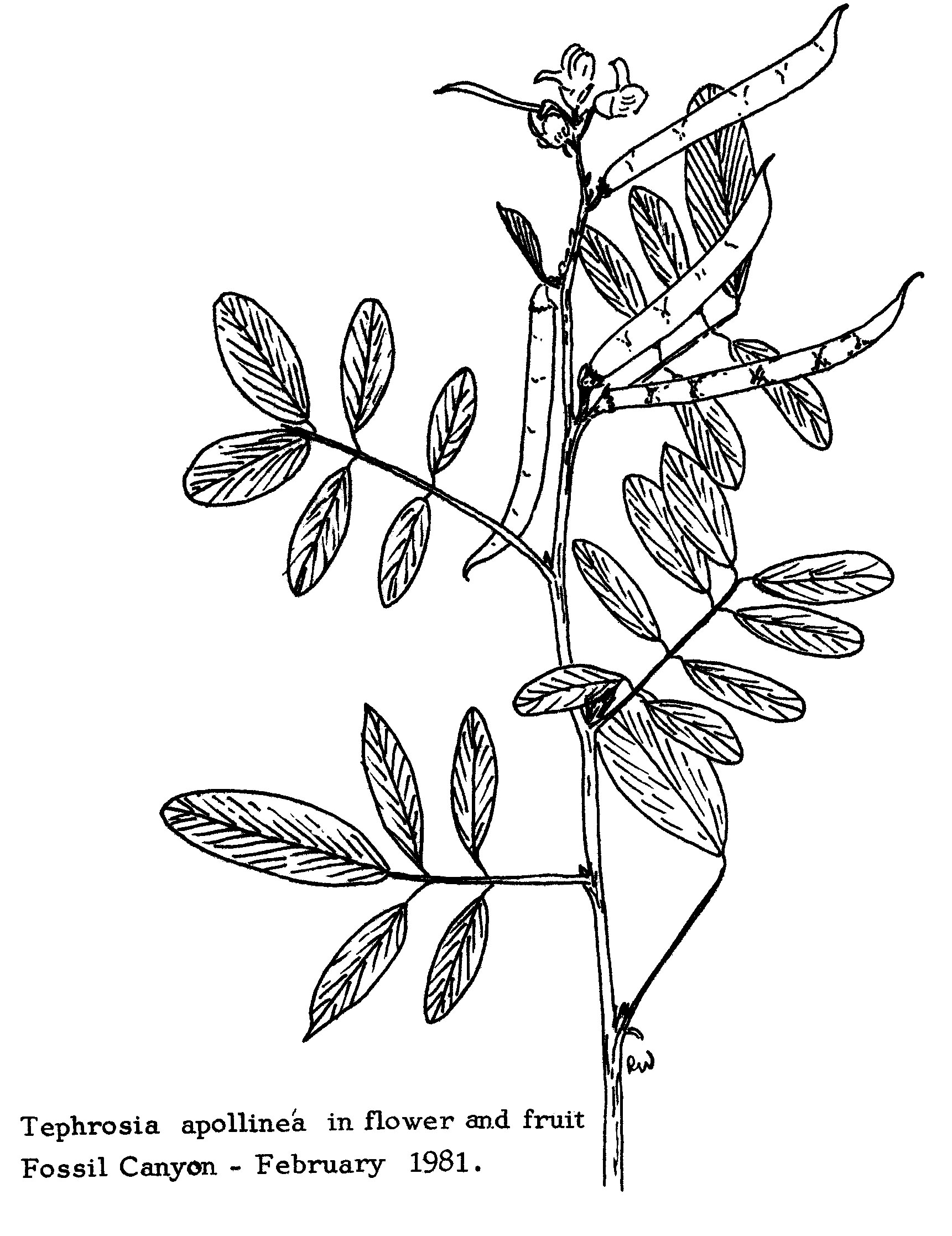
H. elegans lined the banks, and a few examples of dried out, brown bushes of Rhazya stricta were also dotted about. T. apollinea has deep purple papillionate flowers in clusters. The lanceolate leaves are silkily hairy and generally attractive as they tend not be grazed.
In the same wadi are several Calotropis procera trees, up to two metres in height. These were in full flower, the large purple-white blooms covering the outer branches. This tree was known as the gunpowder tree in the past on account of the excellent charcoal-making qualities of its wood. The leaves are very large and light green, giving a lot of shade. This tree is common on sandy soils in the northern Emirates.
Three examples of Citrullus colocynthis were recorded in the basin, two near the wadi and one close to the camp. All three bore the characteristically green-yellow apple-sized fruit, but only the plant near the camp was still in flower. This trailing plant dies off after fruiting. It is an interesting example of adaptation to an arid environment. The leaves are often twisted and always hairy, giving some shelter from direct sunlight, and attracting wind-blown sand to further lessen the effect of the sun.
The jebel surrounding three sides of the basin had its own types of vegetation. Apart from E. larica, a few very stunted acacia bushes grew singly in clefts. A few examples of Fagonia cretica were recorded in sheltered hollows but overall there was no dominant species of plant. In one hollow near the top, facing north, a clump of some ten Cleome glaucescens plants were recorded in full flower. This herb, also of the caper family, was in flower and seed, but was found in only the one location.
One species of Cistanche was noted, probably C. phelypaea but the parasite had a distinct purple fringe to the petals. This plant is common around Umm an Nar in February, also along the east end of the Al Ain road, where its yellow spikes stand out and make it easily recognizable. The plant is attached to a host-plant, usually a salt-bush variety, by a thread up to two metres long under-ground, and through this 'umbilical cord' it draws all its nourishment. The cistanche possesses no chlorophyll and hence there are no green leaves. It is like a leafless hyacinth, though often the petals are in a tight spike.
Grasses were not common throughout the jebel or basin area. Some annuals had clearly died recently but were non-identifiable.
V FaunaMembers of the Group did not expect many recordings during the trip, partly owing to the size of the party, and because very little had been observed in Fossil Valley on previous visits. It was therefore all the more pleasing to record two pairs of foxes gambolling on the lower N slopes of the W rim. One fox had been recorded near the entrance to the valley in March 1978, when it disappeared into a suspected lair. On the occasion of the visit, all foxes observed were in excellent condition. Out in the basin, one hare was put up. This was the first record of a sighting in the valley, though footprints of both hare and fox are common. It is probable that the lack of grass would inhibit a rapid increase in the number of hares, although records from the Al Ain area are not infrequent.
Three lizards were noted but none captured, and hence no firm identification made. It is quite possible that the 'dhub' or spiny-tailed Agamid (Uromastix microlepis) inhabits the more rocky and gravelly fringes but no sightings have been made by the Group to date. However, a large number of droppings that may belong to this creature can be seen on the jebel slopes. This lizard grows up to 60cms. long and has a large flattened body and large spiky tail. Colour is variable but usually dark grey to black, turning to greenish-yellow in the heat of the day. The species inhabits prominent holes and burrows in stony and gravelly areas. Another lizard that had been recorded before but not on this occasion is Agama jayakari, up to 25cms. long. This species is a mottled grey but turns light blue with an orange tail in the breeding season. It is sometimes seen in the top branches of dwarf acacia and Maerua crassifolia trees, basking in the sun. Various geckoes have been recorded in the past, mostly Bunopus species.
No snakes were recorded this time, but an Arabian rear-fanged snake (Malpolon moilensis) was observed in the centre of the basin on New Year's Day 1978 emerging from a rusted tin can. Sand and rock vipers are believed to inhabit rocky areas locally but none were recorded.
Very few birds were recorded apart from a flock of five Purple sunbirds sporting among the flower heads of Calotropis procera trees. These remained in the vicinity throughout the morning but had disappeared by noon. Various groups of sparrows (house?) remained active in the acacias around the camp area all morning. Pale crag martins certainly breed in the hills a few kilometres further east and may also be present in Jebel Huwaya though none were recorded on this occasion. The lack of birds was probably due to the general aridity of the valley at the time of the visit, though scrub cover is never particularly thick at any time of the year. It is likely that the large number of visitors kept birds shy and distant.
VII ConclusionThe visit was not in the best scientific interests of the Group, but many members displayed various degrees of enthusiasm for fossil, plant and bird recordings. Such general visits should perhaps be limited, and recorders visits increased, so that members interested in a specific recording activity can participate more effectively.
- Editor