Bulletin 24 - November 1984: As Safarfir -- An Early Islamic Copper Mine in the UAE
As Safarfir -- An Early Islamic Copper Mine in the UAE
By R.A. WesternIntroduction
Omani sitesParts of Oman have long been recognized as a source for the production and smelting of copper ore. In the third millennium BC, the country possessed large-scale mining operations at Maysar and in the Wadi Jizzi, and both these areas witnessed a revival of the industry in the early Islamic Period. Such was the extent of the operations in both periods that some authorities believe the center and north of the country was denuded of its forests for fuel, and that the resultant ecological devastation can still be seen in Oman's arid landscape today.
During the earlier period at least, if not the second, a proportion of smelted copper was further refined at Hili, near Al Ain, which was clearly an oasis-cum-agricultural site of strategic importance at the west end of Wadi Jizzi. Copper implements have also been found at the contemporary sites of Umm an Nar and Ras Ghanada on the Abu Dhabi coastline. Excavation and research into these sites have firmly established the existence of a local Bronze Age of considerable importance in the history of this corner of Arabia. What is less well documented is the resumption of copper mining activity during the early Islamic period, including sites which are now within the UAE.
Present day mining takes place in the hinterland of Sohar, at Lasail, Bayda and Aarja, and recent research has established that these three sites, along with others, were worked during early Islamic times. Both surface and underground mining were practiced, depending on the nature of the deposits, and occasionally, as at Assayab and Mullaq, the whole of a surface outcrop was systematically removed. It is logical to suppose that at such sties any surface ore was removed prior to the necessity for mining at greater depths, either vertically into the ground or at an angle into the slope of a hill. The present day mines contain an estimated 11-million tons of ore between them with an average copper content of 2.1%. Two further sites expected to be exploited soon are at Darus (600,000 tons with a copper content of 3%) and at Rakah (4.5-million tons-plus with a copper content of 1.75%). After crushing, the concentrate contains approximately 25% copper content. Little analysis has yet been conducted on the ore content on ancient sites in Oman.
Once the ore was extracted, it had to be crushed and on Omani sites crushing slabs and hammer stones are common. Such stones can also be seen in third millenium BC contexts. After crushing, the ore was roasted in shallow pits, groups of three, six, nine and 12 being the usual series since the roasting took place in successive pits according to the grade of ore. These pits were typically bordered by dry masonry and were clay-lined.
The next stage, after burning off sufficient sulfur, was smelting, carried out in furnaces that were always on slopes above the roasting pits and their associated slag heaps. Depending on the site, these furnaces are now in variable states of decay, since erosion from the slope usually resulted in some degree of rock debris. The furnace shafts were lined with stones and mortar, and were usually 1.4 meters high by 0.6 meters wide. The bellows heads consisted of fired bricks and a large air pipe, and the roasted ore concentrate was poured or tipped in from above.
The scale of activity during any one period is difficult to judge. At Aarja, it seems that organization was based on family scale production units, with pits, a furnace and one house per unit. Elsewhere, as at Lasail, there is no evidence of such individual units, and at such sites the houses were concentrated, often on low terraces bordering, or in, wadis. At Aarja, the foundation wall of a small mosque was discovered, and here and at Lasail graveyards, too.
ChronologyRadiocarbon dates from charcoal found in the furnaces and pits give an uncalibrated range from 840-980 AD. There is no vertical or horizontal stratigraphy to give any supportive evidence apart from the early Islamic dates shown by potsherds. A tiny glazed blue shard from Semdah is representative of ninth Century Samarra ware, and unglazed wares are of comparable date. Apparently the operations were reactivated about 150 years later, though on a reduced scale. Much of the best ore was probably worked out in the earlier period. The later sites were characterized by slag fields, rather than slag heaps, the slap originating from simple bowl furnaces in the ground rather than from built-up furnaces on slopes. Radiocarbon dates given are 100 and 1140 AD, and it is possible that earlier slag was reworked. It may be assumed that the vast amount of wood needed to keep the pits and furnaces in operation over a period of up to a hundred years or so in the earlier period must have consumed most of the wood locally available, and that regeneration was hampered by a falling water table and consequent increase in aridity. It is significant that the later operations were always set apart from the original sites, as if there was a need to move to the nearest convenient source of timber.
As Safarfir -- The SiteAs Safarfir lies in the south of Ras al Khaimah on the Wadi Safarfir, a few kilometers west of Huwailat and north of Hatta. There is no modern day community in the immediate vicinity but the site is bordered on the east by a recently established garden complete with its own well. There is no permanent dwelling here yet, but one or two laborers are in regular attendance. Apart from the garden, it would appear that the area has not been inhabited or cultivated in recent years, though a rough shelter on the south bank of the wadi opposite the garden was probably used seasonally to work a now-abandoned area of low terraced fields. A track runs along the wadi bed and another parallel to it on the north side, and these lead to isolated encampments further west in the hills.
The site itself is extensive, and follows a pattern of activities clearly very similar to those described above for Oman. The original site, complete with mine entrance, roasting pits, furnaces, settlement area, and graveyard, is to the west, while a secondary and apparently more recent site lies to the southeast. The main settlement site is on an east-west axis, towards the western end. This settlement is a unifying factor, running the full length of the site, and is between the production and processing area. (See Fig. 1)
The MineLocated on a steep slope some 20 meters above the south bank of Wadi Safarfir, the mine shaft is today represented by a vertical opening which is just 5.8 meters deep and 2.7 meters in diameter, with a neat circular outline. There are no existing steps or other means of descent. The bottom is fairly level and filled with a mixture of rubble, silt and dead branches of Physorrhynchus chamaerapistrum which have been blown in. It is not known whether this infill conceals a deeper shaft running horizontally into the hill, but certainly the mounds of spoil and broken ore around the shaft indicate that a lot more came out of the mine than the present volume of the shaft indicates, particularly as most of the ore would have been transported across the wadi to the roasting pits.
To the east of the shaft, some 20 meters away, are the remains of at least three separate square and rectangular rooms or dwellings. These structures are now only one stone (15-20cm high), on a north facing declivity. More rubble heaps surround them but there is no evidence of any further mine entrance. From the shaft down to the wadi is a line of steps cut into the slope, faced with small wooden boards to hold their position against erosion. It would appear that these boards must be relatively recent, to judge from their state of preservation.
The Roasting PitsDirectly across the wadi from the mine shaft lies the western end of the settlement terrace, about 100 meters away. The roasting pits are situated about 25 meters to the north of this terrace and some 110 meters further east. Two of the three pits closest to the settlement area have recently been excavated, perhaps by the de Cardi archaeological survey in 1982. Another five meters beyond these three pits, which are surrounded by heaps of slag, lie at least 17 more pits, very close together, some of which have apparently been partially excavated. These pits are roughly oval with a mean short axis of 1.45m and long axis of 2.1m. None of these structures displays any evidence of dry masonry lining, but this could have been removed in the course of excavation. There is much less slag around the 17 higher pits. One hole has a Fagonia indica shrub growing in it, an indicator perhaps of recent excavation since this species tends to be among the first colonizers of disturbed ground.
Lying between the pits and the settlement terrace is a rough circle or ore stones, about 5.7m in diameter, which was undoubtedly a store of raw material for the roasting process. This now deflated heap consists largely of chunks of vein quartz bearing traces of copper mineralization (copper hydroxide and/or carbonate). Smaller rocks of specular haematite (FE2O3) with some interstitial calcite were also found at this location. No obvious crushing slabs or hammer stones were recorded in the area.
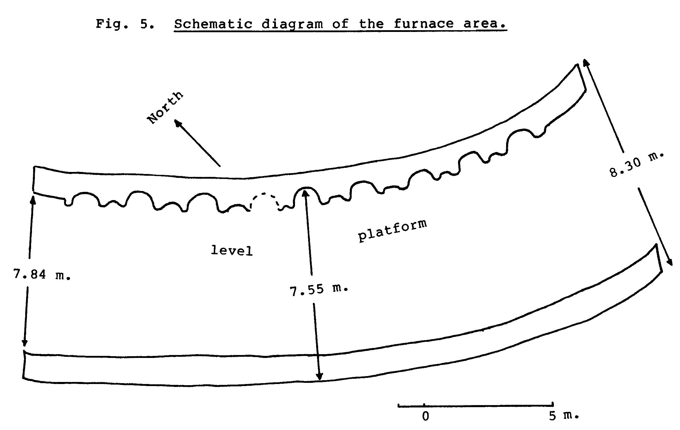
The FurnacesSome 60m west-northwest of the pits are the remains of at least nine furnaces set in a convex line extending along the crest of a slope. The rounded back parts of eight of these furnaces are still very distinct, set into a 21m long, 1m thick bracing wall which rises just above the slope summit. This wall, like all structures at As Safarfir, is constructed of local stones and smooth wadi rocks, and like some of the more substantial structures, contains an infill of smaller stones, pebbles and gravel. The immediate surrounds of each furnace consists of rock debris, but in front is a hard-packed roughly level surface 7.55m wide extending to a second thick wall 24.4m long, parallel to the wall comprising the rear of the furnaces. This second wall is set into the slope to prevent any erosion of the platform, presumably a working surface for those working with the furnaces.
From the top of the furnace shaft to infill the present maximum height is 0.6m and the maximum furnace width of the eight obvious furnaces is 1.31m. Very little erosion has taken place except at the east and where both walls have been cut by a gully some 3m wide and 1.4m deep. In the vicinity of the furnace, pieces of medium to coarsely crystalline olivine gabbro, one of the more typical basic igneous rocks of the area, are common, and also obvious by their color are lumps of reddish-brown altered igneous gabbro, now largely haematite but also containing serpentine and silica with bastite pseudomorphs.

The Settlement
Between the roasting pits, furnaces and ore heap on the one side, and the main wadi on the other, lies the 300m long raised settlement terrace. Most of the structures exist in foundation form only, but some substantial lengths of walling can still be seen. There is little apparent relationship now among the mounds of boulders, stone rectangles, squares and circles, but in their time some of them must have been of importance, because of their outline size or configuration. At the west end of the terrace is a neat rectangle with one longer side facing west and with an entrance with a flat foot-stone in the middle of the opposite side. Outside measurements are 7.7m by 5.3m and the doorway is 0.71m wide. The walls are between 0.62 and 0.69m thick, composed of two thin layers of small boulders with an infill of pebbles and gravel. One may speculate as to whether this was a mosque.
About 40m further east is another imposing structure, comprising several rectangles within a rough circle of rock debris 16.8m in diameter. Inside this circle are the remains of at least five separate rooms, the largest measuring 5.32 by 2.94m. Part of the outer north side consists of a straight wall 5.34m long and some 44cm high. At the east end of the circle is a large raised platform in the shape of a bulge, which was probably the main entrance to the complex.
Approximately 60m in from the western end is another well-defined structure measuring 4.48m by 4.37m. This oval structure is situated at the highest point of the settlement, about 2m above the west and east extremities, and from here the terrace bends further towards the east. This higher area contains many circular structures and is about 11m in from the bank of Wadi Safarfir and some 9m in from a shallow wadi system on the north side. The best preserved stretch of walling on the whole site lies some 25m east of here, consisting of 12 large boulders obviously selected for their straight edges (there is no sign of any dressing) plus a large corner stone. This section, set very solidly into the ground, is 7.76m long. Towards the east of the settlement, the structures are smaller and less defined with many half circles and odd heaps of stones. The eastern limit is demarcated by a number of large boulders beyond which the shallow wadi to the north of the settlement curves around to close off the terrace and fan out into Wadi Safarfir, near the recently-established garden. Just outside this stone boundary lies a final rock circle approximately 1.6m in diameter.
The whole site enjoys easy access though several of the structures are overgrown with Acacia tortilis trees, and Lycium shawii and Fagonia indica shrubs. Along the margins of the main wadi are a number of healthy Ziziphus spinachristi trees, a few of them draped with the creeper Pentatropis spiralis. One or two clumps or rushes, indicating some water flow beneath the wadi gravel, can be seen close to the east end, but not associated with the garden. The surrounding hills are bare with a thin cover of perennials including Euphorbia larica, stunted Acacia trees, Fagonia indica, Jaubertia aucheri and grasses (especially Cymbopogon parkeri, Aristida adscensionis and Stipagrostis plumosa). Annuals are prolific after wet springs, particularly composites. It is hard to imagine the region as a forest but undoubtedly it must have been at one time.
The GraveyardThe graveyard at As Safarfir is situated on a flat terrace some 40m northeast of the furnace area. There are 26 graves marked out by stones in a compact area 28.7m long by 9.5m wide. The graves are dotted along this rectangle, apparently at random, sometimes almost touching, sometimes in isolation; they are most dense towards the western end, sometimes lying three together head-to-toe across the width. Most of them are elongated ovals and several have raised stones inside at both ends. Their axis is roughly east-west. None of the graves appears to be recent, since any original mounds have long since been leveled by natural forces to the surrounding surface. The best preserved measures 2.58m by 1.3m and consists of 19 boundary rocks and two small standing stones, one at either end. This grave is narrower at the eastern end.
Further StructuresSome 100m north of the graveyard, over a small ridge, is another small but steep-sided wadi running parallel to Wadi Safarfir. On both sides of this gully lie a number of sunken rectangular and circular rooms over a distance of 90m. the two best preserved are on the south side and measure 3.41m by 1.92m and 4.13m by 2.15m respectively, with entrances on the south side. The rooms were cut into the slope and securely lined with wadi boulders. It is not known if these structures are contemporaneous with the mining site, or whether they are more recent, but unglazed red shards recorded at both sites are in some cases very similar.
Safarfir SoutheastA kilometer or so downstream from the mineshaft, and also on the south bank of Wadi Safarfir, is an extensive site that might represent a period of secondary copper processing, corresponding to the early 11th Century sites in Oman. Slag fields are in evidence rather than slap heaps, and among them are what could be the remains of shallow pits, though this could have to be confirmed by excavation. Stone structures are numerous and to the southeast area series of old terraced fields, but there is no sign of any furnaces and virtually no ore compared with As Safarfir proper. This second site, which we refer to as Safarfir Southeast, is partly situated on a promontory near where the Wadi Safarfir turns sharply to the northeast towards its confluence with Wadi Al Qawr. The south end of the site is bounded by the steep hills and a steep-sided wadi running south-north into Wadi Safarfir. This narrow wadi has permanent water a little further south into the hills.
The PotteryAlthough a lot of shards are still scattered around As Safarfir, none is large and most are nondescript in appearance. A few are rim or base pieces or recognizable as part of a handle. Glazed shards are particularly abundant among the structures associated with the highest part of the settlement. No shards were seen in the area of the graveyard or around the mine shaft. All shards recorded are surface finds and given the nature of the whole site and its state of ruin, it is highly improbable that any pottery vessels or shards will be found in a stratified context.
The surface shards appear to fall into seven categories according to type.
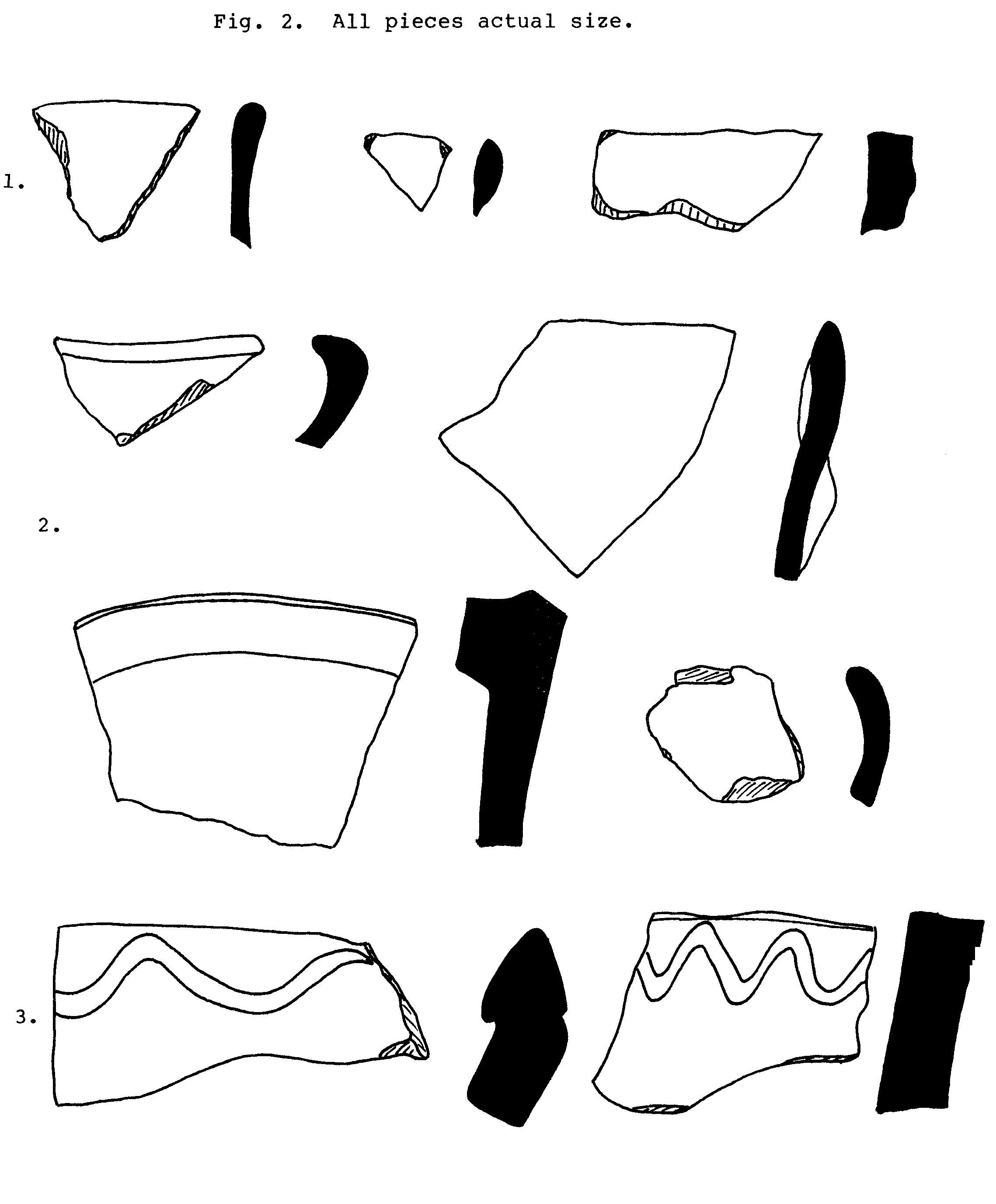
Glazed Wares- Mostly very small, irregular shards with a bright or dull aquamarine glaze on both surfaces, which occasionally becomes a spotted gray on the inside. One piece, apparently from a plate base or similar, has a white glaze with parts of a design superimposed in aquamarine. Rims are glazed over. 0.5 - 1.0cm thick. (Fig 2, No. 1)
- Glazed white or cream on both sides, the glaze usually with a cracked appearance. This category includes many base pieces and one or two small rims (cups?). The glaze occasionally merges to dull gray, though one shard was creamy yellow. 0.5-1.0cm thick, but up to 1.75cm for thicker bases. (Fig. 2, No. 2)
Unglazed Wares
- Thick white shards, many of them rim pieces with a reddish-brown interior biscuit. Several bear a characteristic wavy lines, like an elongated 'S', running around the outside rim. 1.25-2.50cm thick. (Fig.2, No. 3).
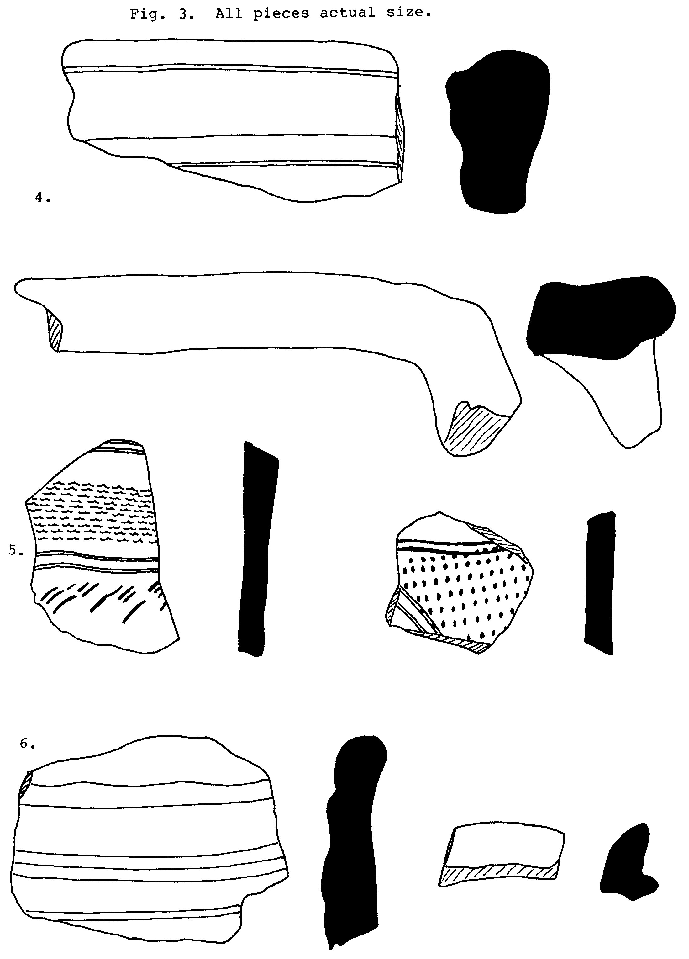
- Very occasional larger pieces of white or cream ware, representing either handles or larger rims, sometimes with raised collar on the outside. Up to 2.50cm thick. (Fig. 3, No. 4)
- Thin buff ware decorated with thin parallel lines interspersed with dot or stipple marks etched directly into the wet clay before firing. Recorded on a large number of sites throughout the Emirates and possibly more recent. Some wavy line decoration occasionally present. 0.50 - 0.75cm thick. (Fig. 3, No. 5)
- Thick brown ware with parallel horizontal line decoration and smooth inside surfaces indicative of wheel manufacture. 1.0-1.25cm thick. (Fig. 3, No. 6)
- Thin brick-red ware with dark red or purple painted lines on the outside. Usually diagonal lines between horizontal lines going around the vessel. Perhaps the commonest ware on the site, and also recorded at Safarfir Southeast, and at other abandoned sites in the hills throughout the Emirates. 0.5 - 0.75cm thick. (Fig 4, No. 7)

Note: Surveys of As Safarfir were carried out in July and August 1984 with the help of J.N.B. Brown. Vegetation recorded on the site refers to this period only.
For the information on sites in Oman, I am indebted to Gerd Weisgerber's article "Patterns of Early Islamic Metallurgy in Oman", in Proceedings of the Seminar for Arabian Studies, Vol. 10, 1980.
Brian Doe's and Beatrice de Cardi's article "Archaeological Survey in Southern Ras al Khaimah, 1982 -- Preliminary Report," in Proceedings of the Seminar for Arabian Studies, Vol. 13, 1983, is an invaluable reference for Islamic and pre-Islamic sites in the area.