Bulletin 26 - July 1985: A Brief Introduction to the Geology of the United Arab Emirates
A Brief Introduction to the Geology of the United Arab Emirates
by E.R. Aston[Because of the number of maps and other illustrations associated with the article, the images have not been included in the page you download. There is a link to each image embedded in the text. There is also a convenient 'Back' button associated with each graphic. -- web/ed]
Emirates LandscapesThe Emirates landscape splits naturally into two distinct regions - the vast areas of recent sediments (Gulf shoreline and desert) and the narrower, but magnificent, mountain chain.
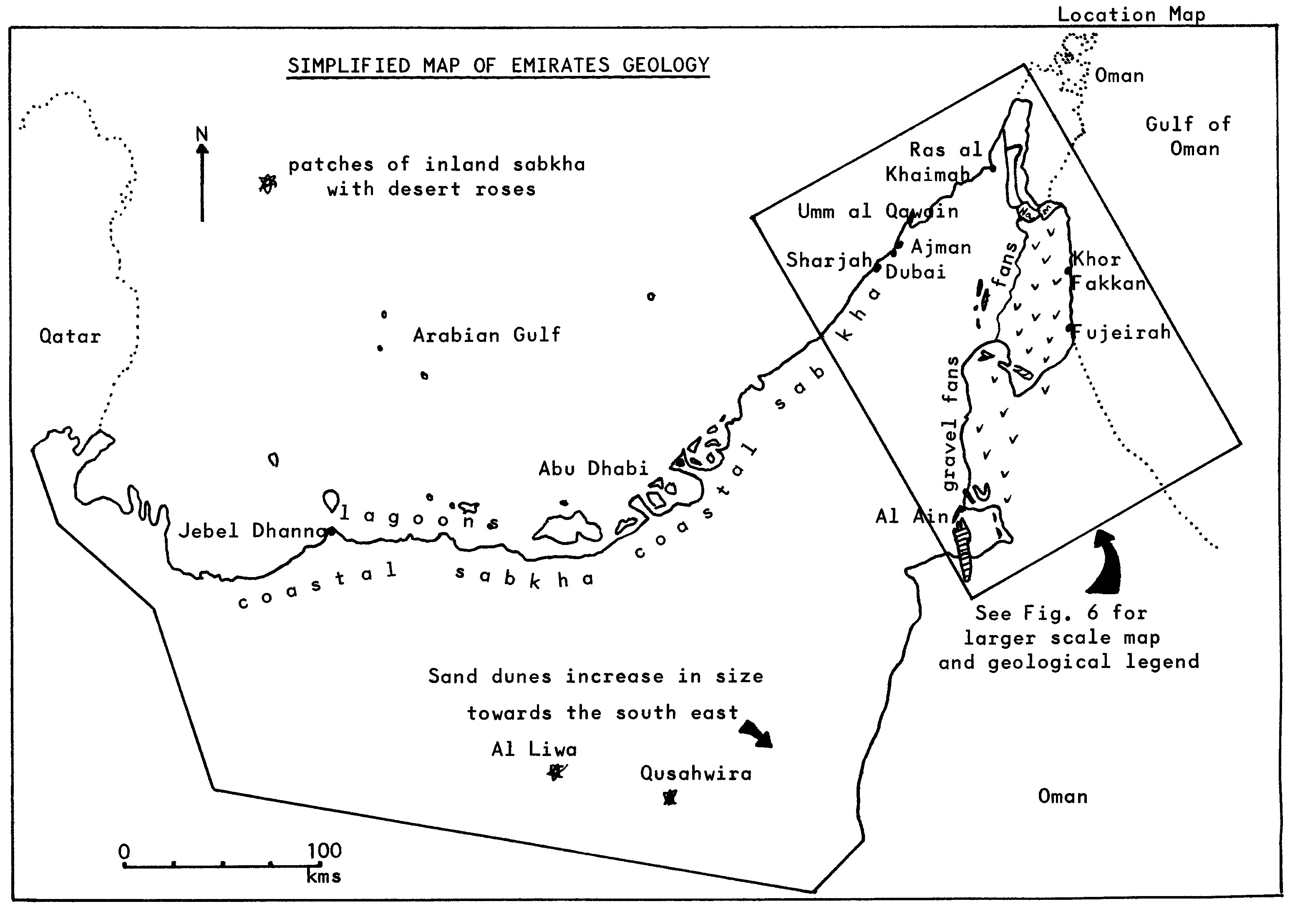
The Gulf shoreline is a classic carbonate barrier coast and for this reason it is visited regularly by eminent geologists who come to study the modern-day equivalents of many oil-bearing reservoir rocks.
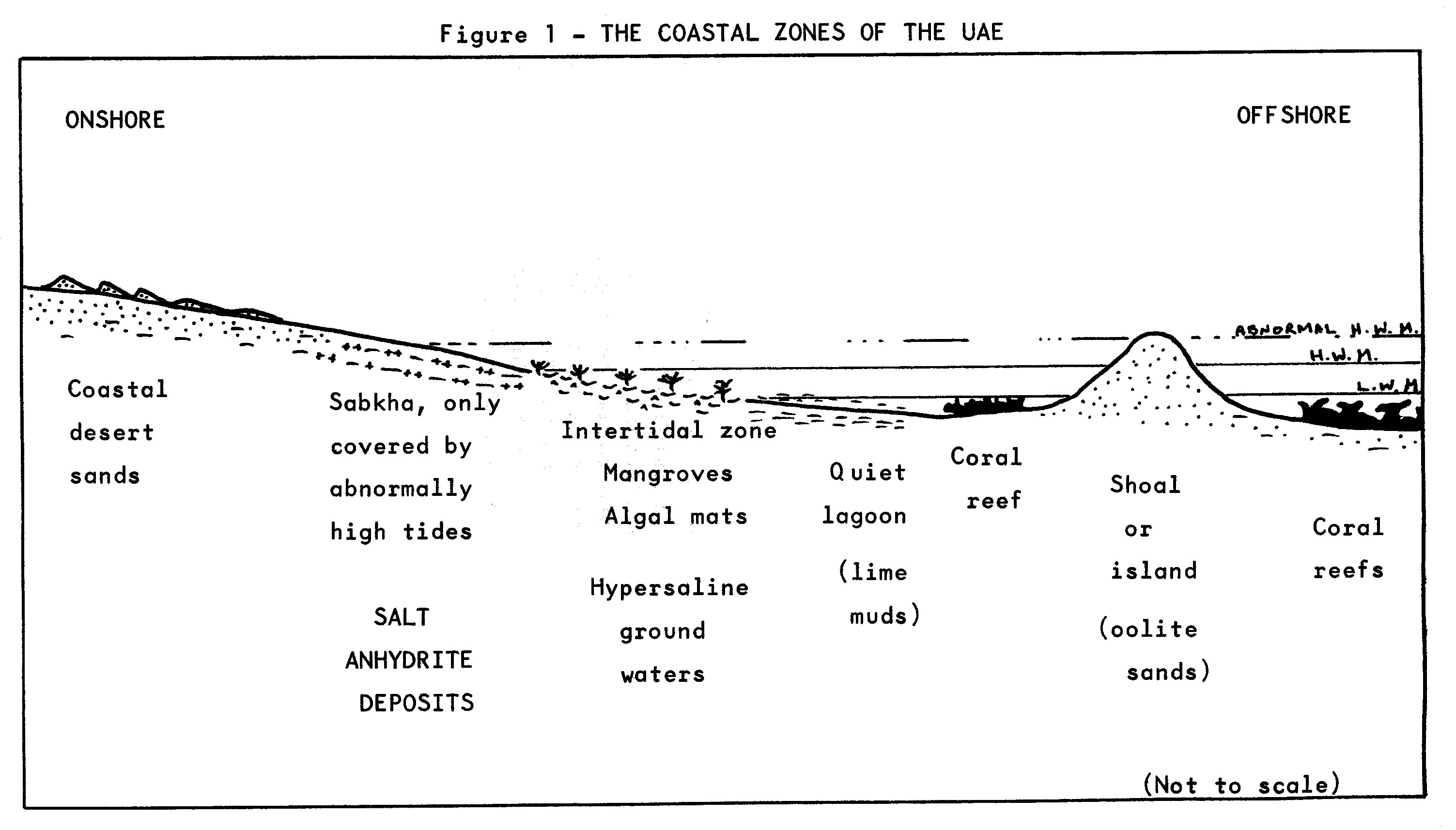
The Gulf waters contain many coral banks and reefs although the number of species of coral and other shell-life that can tolerate the high salinity is few. These coral patches give way to a series of fringing islands which stretch south westwards from Gharab, Sadiyat and Abu Dhabi to Halat al Bahrani, Abu al Abyad, and to Bazm al Gharbi. Rounded grains of lime (called ooliths) are washed by currents and waves driven by the dominant northwest trade winds into shoals and islands that protect the lagoons behind.
The shallow waters of the lagoons cover vast areas that fill and drain with each tide. As this great volume of water drains through only a few channels, so the currents within these channels become very strong (often as much as five knots). Small pockets of mangrove grow along the edges of the lagoons and a black, mat-like area of a primitive species of algae, often mistaken for oil pollution, forms along the tidal limits of the lagoon.
Behind this lie the extensive salt flats known as 'sabkha' that are only covered by the sea during freak storm conditions. This coastal complex is backed by recently abandoned salt flats and a series of low escarpments of Tertiary rocks (called the Lower Fars limestones) that can be seen along the Abu Dhabi-Tarif road.
Behind these low escarpments stretch the vast trains of sand dunes that slowly move south eastwards blown by the ever-present northwest winds. The dunes vary in size and color. Near the coast they are cream to buff but towards the interior they become a deep red-brown color, as at Al Ain, along the Al Ain-Dubai road and towards Dhaid. In the southern part of the Emirates, the dunes become giant-sized as near Al Liwa, Qusahwira and Al Hamrah. This is the northeastern tip of the Empty Quarter (Rub al Khali). The red-brown color of the sands is due to oxidizing conditions of the arid climate. The sand grains often have a thin gray coating of clay that is oxidized to a rusty ferric iron material. These sand dunes are separated by areas of gravel - the coarse grains and pebbles that the wind cannot move, or by areas of inland 'sabkha' within which the lovely 'desert roses' form. Desert rose is the name given to a form of interlocking crystals of gypsum (CaSO42H2O - the same mineral as plaster-of-Paris). The crystals grow easily but slowly in the sub-surface ground waters where evaporation has caused the salinity to be sufficiently high for the mineral to precipitate.
Backing this desert scene is a long range of stark, jagged mountains from which huge fans of gravel and boulders spread out, as near Shwaib and Al Madam. The present-day scenery is a relic of post-Pleistocene times (i.e. since the Ice Age) when the climate was far wetter than today. Large rivers raced off the mountains distributing vast amounts of pebbles and boulders as huge fans abutting the mountains and filling up the valleys to form almost flat-topped boulder beds. As the climate became warmer and drier again, the rivers became smaller. At this time also, the land generally uplifted a little and the rivers cut down through these ancient fans and boulder beds to form modern small but impressive wadis, as along the Masafi-Fujairah road and those wadis southwest of Dibba.
The surface boulders and pebbles have lain baking in the sun for several thousand years. They have been polished smooth by the desert winds and have 'sweated out' iron, magnesium and manganese salts to produce a distinctive black mineral surface and a dark appearance to the plains, as inland of the Fujairah-Dibba road.
The hard rocks of the sub-surface are several thousand meters thick. They are mainly limestone (often oil or gas-bearing), evaporates, shale and sandstones, similar to those that are accumulating at the surface today (Gulf coastline deposits backed by desert sands). The ancient seas in which these sediments accumulated have fluctuated during the last 500 million years. Sometimes they extended as far as the Saudi Arabian massif, at other times they shrank to less than their present extent.
The mountains of the Saudi Arabian desert separate the desert from the Red Sea and African continent nowadays as they have done for the past hundreds of millions of years. However, the UAE-Oman mountain chain has only been a barrier for the last 15-20 million years.
The Arabian Peninsula has moved gently around the Earth's surface, but has always remained or near the tropical zones. The climate and seas have therefore usually been warm tropical or subtropical often with desert lands bordering them.
These deeply buried sediments that depict this history of ancient Gulf desert regimes lie beneath the blanket of recent deposits. Individual beds of rock spread for miles like a layer of a cake, extending from Saudi and Qatar through Abu Dhabi and across, beneath the Gulf waters, towards Iran.
During the mid-Tertiary times earth movements folded and tilted these rocks and sometimes they break through the recent cover to form scenic mountains or 'jebels' as at Jebel Hafit, where Oligocene and Eocene rocks outcrop; and at Jebel Huwayyah, where Upper Cretaceous rocks are present.
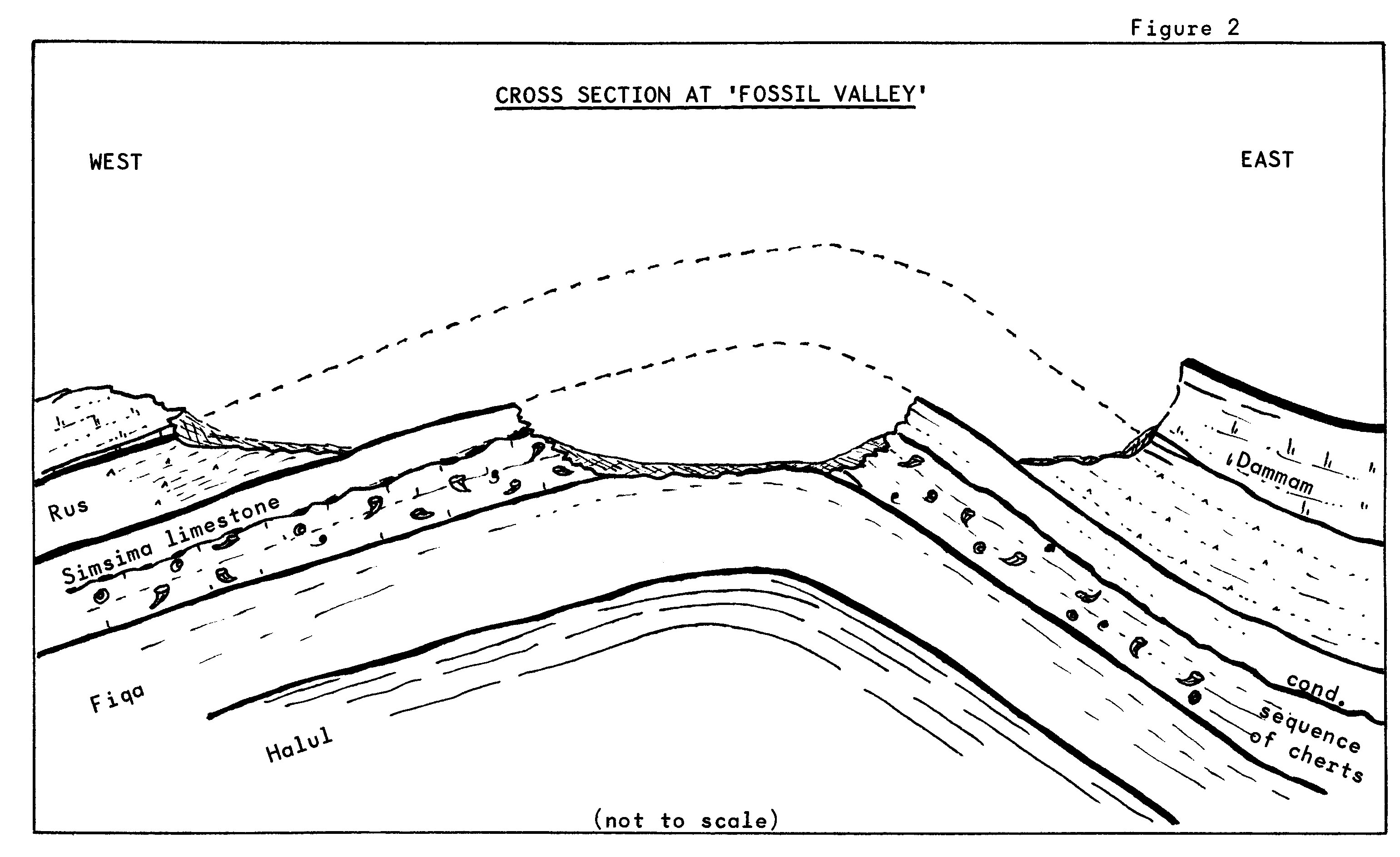
One of the most interesting of the jebels for many people is Jebel Huwayyah - also known as 'Fossil Valley'. This is an eroded anticline, an arched fold of rocks that has exposed the Upper Cretaceous Simsima limestone. This forms the horseshoe of hills along the southern end of the valley. This locality was the site of a shallow offshore reef some 70 million years ago.

The most common fossils to be found are corals, rudists (a type of oyster which looks like a coral), many types of clams and oysters, and large gastropods (sea-snails). Occasionally echinoids (sea urchins) occur and very occasionally ammonites (sea animals related to a squid which lives in a flat-coiled shell). Similar fossils also occur at Jebel Fa'Iyyah.

At the time these animals were living, Abu Dhabi lay more or less on the Equator and faced due north rather than its present northwesterly outlook.
Below this thick sequence of ancient sediments lie even older deposits of salt (Basal Cambrian - 600 million years old). Once sufficiently buried, such deposits of salt become mobile due to the pressure of overlying sediments. The salt then tends to move upwards at a very weak point towards and into an area of low pressure. In this way, huge columns of salt can rise slowly towards the surface bringing up with them associated rocks from great depths (sometimes from as deep as 6000 meters). Such salt structures pierce the surface today at Jebel Dhanna, Sir Bani Yas, Das, Zirku and many other islands.
The salt washes away leaving behind the other rocks and minerals which formed at that time - particularly gypsum (varying from colorless or white to yellows, browns and to deep red where iron stained); hematite iron ore (a flaky or platy, brightly shiny, heavy mineral); the common rocks are lavas, mauve and green shale. Small amounts of yellow crystalline sulphur also occur. The iron content can be so great as to give rise to dark red mineral sands as on the island of Sir Bu Nu'air. Reports suggest that salt was mined in historical times on Sir Bani Yas, where antimony ore was also found and ground down to make an eye-soothing powder called kohl.
The UAE-Oman mountain zone is a separate and distinct geological entity. It comprises an unusual suite of oceanic rocks that are rarely found on the continental surfaces of the Earth. These rocks (lavas, oozes and oceanic crustal rocks) are believed to have formed at the site of a mid-oceanic ridge (where the Indian Ocean now lies) more than 70 million years ago.

Great forces below the earth's crust slowly but continually keep the surface of the planet moving. Such forces are believed to have dragged this segment of oceanic crust, and the lavas and sediments on top of it, towards Arabia, and to have then thrust it in slices onto the edge of the Arabian Peninsula. This would have taken some time to accomplish (20 million years or so) and it is believed to have taken place during Cretaceous times.
The ancient lavas and oceanic crustal rocks were altered during this journey with its thrusting and are now the green-gray ophiolites and brown altered gabbros of the steep, dark, magnificent mountains south of Dibba and Masafi. In places, the offshore sediments have been baked, subjected to great pressures and altered to hard quarztites, marbles and schists. The folding associated with thrusting can be seen in the folded schists of Uyaynat gorge, north of the Dibba-Masafi road. In the mountains north and west of Dibba, the near shore oceanic sediment slices extend a long way into their present position. To the north, stretching through the mountain belt towards Ras al Khaimah, are the near shore sediments associated with this same ancient ocean (Tethys). These are the gray and buff well-bedded limestones to the east of Ras al Khaimah, as in Wadi Bih. They have been folded and faulted but have been thrust but a short distance.
Once the oceanic lavas have been forced on top of the Arabian massif, they formed a seabed for more limestones to accumulate. Such an ancient seabed surface is called an unconformity. The road to Hatta and through Jebel Fa'Iyyah show Upper Cretaceous limestones sitting on the older seabed of lavas. The same earth forces which have thrust these slices of oceanic crust and sediment onto the Arabian Peninsula also pushed up the adjacent sedimentary layers into the steep folds which run along the western edge of the mountains - Jebel Huwayyah, Jebel Hafit and so on. Once these forces died away, the area rose above sea level (during the mid-Tertiary times), since when the mountains have been progressively eroded.
Thus the geology of the Emirates is one of extremes. One the one hand are the thick sequences of limestones almost identical to the modern coastal deposits that have had a peaceful existence for the past 500 million years and more. On the other hand, there are the oceanic lavas and sediments which formed at very great oceanic depths, traveled long distances, and were thrust onto the Arabian land mass - all in a far shorter period of time (less than 100 million years) and the accompanying notes detail the places of geological interest.

It is rare that such a small country can offer such a wide selection of rocks, rock structures and varying scenery. Anyone who has the opportunity to travel is recommended to do so to appreciate the full range of landscapes.
Interesting Geological Localities mainly accessible by saloon car
A Jebel HafitA twelve-kilometer-long anticline of impressive Eocene limestones, running south from Al Ain into Oman. The surrounding foothills comprise Oligocene limestones.
B Jebel Huwayyah (Fossil Valley; Horseshoe Valley)Strictly speaking in Oman, about 5kms northeast of Buraimi, but readily accessible from Al Ain. It consists of a horseshoe of hills comprising Upper Cretaceous limestone (Simsima Limestone), the site of an ancient reef some 67 million years old. This reef provides abundant fossils, especially rudists, other bivalves, gastropods, corals, echinoids and, rarely, ammonites. The impressive cliffs to the east are an escarpment of Jebel Qatar.
C Hatta AreaAccessible due east from Jebel Ali near Dubai, or from Abu Dhabi and Al Ain via Al Hair, Shwaib and Madam roundabout. Beautiful mountain scenery surrounds Hatta, with numerous peaks of volcanic rocks and metamorphosed and folded ancient sediments (known as the Maqam or Dhera Formations). Note the unconformity to the north of the road approaching Hatta at the beginning of the mountains, near the signpost to Al Rawdah Quarry.
D Jebel Fa'Iyyah (Fossil Mountain)Near Mileiha, south of Dhaid, this consists of a series of small jebels comprising Upper Cretaceous Simsima limestones, again very fossiliferous. These limestones overlie lavas which once formed the ancient sea floor on which the sediments accumulated. A navigable track leads west from the south end of Mileiha village.
E Wadi SijiA good road to Siji is signposted from Dhaid-Masafi highway. Siji is a popular visiting spot with impressive mountain and wadi scenery formed by dark oceanic lavas formed some 125 million years ago.
F Wadi HamSnaking beside the main road from Masafi to Fujairah the Wadi Ham is dominated by striking mountain scenery. Old boulder beds have been cut into by modern wadis to give very steep-sided modern wadi systems.
G Khor Fakkan CoastThis is a beautiful coastline between Dibba and Fujairah on the Gulf of Oman, with steep mountains plunging into the sea. In places there is a narrow coastal plain comprising dark smooth gabbros boulders. These dark rocks are the ancient oceanic crustal rocks that were altered during the thrusting to their present position.
H Uyaynat Gorge (Dibba Gorge)The original Masafi-Dibba road passes through Uyaynat, and now provides a pleasant stroll and picnic spot. The rocks are mainly green schists displaying good folding structures. In the upper reaches of the gorge, other metamorphic rocks occur, including quartzite.
I Wadi SidrSituated in the mountains between the Masafi-Dibba and the Manama to Ras al Khaimah roads, east of Ghayl, this wadi passes through a rapidly changing geology. Starting with small segments of ancient sediments, the higher reaches pass through metamorphic and altered gabbroic rocks complicated by thrust planes.
J Wadi Al BihA long and complicated wadi system penetrating into the steep mountains of beds of ancient sediments northeast of Ras al Khaimah town. Rocks vary from Triassic (or even Permian) to Jurassic and Lower Cretaceous in age and form very impressive mountain scenery.
K Wadi HagilSituated in the hills east of the Ras al Khaimah-Sha'am road, large trace fossils in brown limestones (known as the Triassic Elphinstone Group) can be found just to the northwest of the wadi entrance.
Desert Roses
These can be found in the subsurface of the inland sabkha areas of Al Liwa and Qusahwira.
Please note that it is courteous to wear suitable clothing for an Arab culture. Also no right of access is implied by these notes. Further, no right of removal of fossils, minerals or rock items is acknowledged.
(Liz Ashton was the Group's Geology Recorder until her departure from Abu Dhabi last May. She was responsible for the geological display in the workroom. -Ed.)