Bulletin 29 - July 1986: The Content and Nature of Arabian Gulf Seawater
The Content and Nature of Arabian Gulf Seawater
by Roger BrownPreface
Earlier this year a talk was given to the ENHG (Abu Dhabi) on the content and nature of Arabian Gulf seawater. Research for this talk has led to the writing of this paper. Technical literature on the subject is somewhat limited however, some references are given for further study. Reference is also made to theories developed by the author which although supported by initial research have not yet been fully validated. This paper is divided into two sections, with this Bulletin edition dealing with chemicals, weather and tidal effects. The second part will look into microscopic marine life.
Part 1: Chemical, Weather and Tidal Effects
IntroductionThe world's oceans are many billions of years old and occupy nearly 71% of the Earth's surface. In contrast, the Arabian Gulf is relatively new at 3.5 billion years and small in comparison at only 0.072% of the total seawater area. The Gulf has had a varied history. Some 20,000 years ago it was reduced to the state of an estuary, and it only reached its present level about 5,000 years ago.
Essentially the Arabian Gulf is an enclosed area of water with evaporation (due to temperature and wind) exceeding the freshwater input from the Rivers Tigris and Euphrates. Hence there tends to be a continuous inflow of seawater from the Gulf of Oman via the Strait of Hormuz. This flow increases the salt level within the Arabian Gulf, accounting for the high salinity levels present. This salinity tends to stabilise due to salt precipitation -a well-understood feature of the Gulf.
Topographical features of the area plus the prevalent weather patterns give rise to other interesting features.
Gulf Seawater AnalysisTable 1 shows a table of the main chemical content of Gulf seawater at two sampling points, Abu Dhabi and Kharg Island. The total dissolved solids in seawater are approximately 6% higher in the Abu Dhabi area, a figure which is acceptable given the natural intermixing of fresh river water and salt water at the top end of the Gulf. Such mixing will not be noticed in the Abu Dhabi area because of its distance from the fresh water source and the fact that total evaporation exceeds the fresh water input.
During the ENHG talk, laboratory tests were conducted on samples from Abu Dhabi coastal water, the fresh water spring at Ain al Faidah near Al Ain, and from Abu Dhabi tap water.
| Sea Water Analysis (Arabian Gulf) The following constituents are in milligrams per litre. | ||
| Constituents | Abu Dhabi (Zakum Oilfield) |
Kharg Island |
| Chloride | 24 300 | 23 000 |
| Sulfate | 3 420 | 3 100 |
| Bicarbonate | 200 | 171 |
| Carbonate | -- | 24 |
| Sodium | 13 900 | 13 044 |
| Magnesium | 1 560 | 1 500 |
| Calcium | 600 | 520 |
| Iron | 0.3 | -- |
| Total dissolved solids | 43 980.3 | 41 359 |
| (Abu Dhabi coast) | ||
| pH | 7.8 | 8.2 |
| Specific gravity | 1.029 | 1.031 |
| Temperature 'C | 23 | 23 |
Table II
| Results of Water Sample Tests The following results were obtained during a series of tests conducted on water samples from the Abu Dhabi coast, the fresh water spring at Ain al Faidah (Al Ain), and Abu Dhabi tap water. Tests were conducted at the St. Andrew's Community Center, Abu Dhabi, on 3 March 1986. |
|||
| Measurement | Sea Water | Spring Water | Tap Water |
| Temperature 'C | 23 | 23 | 23 |
| Specific gravity | 1.029 | 1.002 | 1.000 |
| Salinity and NaCl | 5.0 | 0.8 | 0.0 |
| pH | 7.80 | 7.97 | 8.25 |
The equipment used was as follows:
Temperature: Mercury thermometer +/- 0.5'C accuracy.
Specific gravity: Hydrometer +/- 0.001 g.u. accuracy
Salinity and NaCl: Salinity hydrometer +/- 1 percent accuracy
pH: Gallenkamp Electronic pH state meter 0.01 pH unit accuracy
The results of these tests are listed in Figure 2. As expected, the tap water sample showed zero salt (NaCl) content and a specific gravity reading of 1.00. Surprisingly, salt was found in the sample of spring water from Ain al Faidah, and this was clearly detectable by tasting. The 5% found in the Abu Dhabi seawater sample was considered reasonable for this time of year (late winter). According to our reference data, salt content in the Gulf varies between 5% and 7% in winter, compared to about 3.5% for the Gulf of Oman.
Weather Effects
Weather has an important effect on the seawater of the Gulf. Predominant wind flow across the water surface in conjunction with tidal patterns creates wave action. Oxygen -- a prime requisite of many marine life forms -- becomes infused in the sea due to the breakup of the surface water skin through wave action (surf).
Continuous sunlight, particularly in the summer months, warms the water surface, causing evaporation levels to increase. The combination of both wind and solar energy can lead to very high evaporation levels, especially in shallower and lagoon areas. It has been said that the total annual input of fresh water from the Tigris and Euphrates is less than that which evaporates from the surface of the Gulf. This is compensated for by inflow from the Gulf of Oman, estimated at 500 metres/hour flow rate through the Strait of Hormuz.
A strong wind in one direction can affect tide heights. This is particularly noticeable along the Abu Dhabi coastline when a northwesterly is blowing. Such a wind, if strong enough, can push water into the Abu Dhabi/Qatar/Das basin, raising the tide substantially above the predicted level.
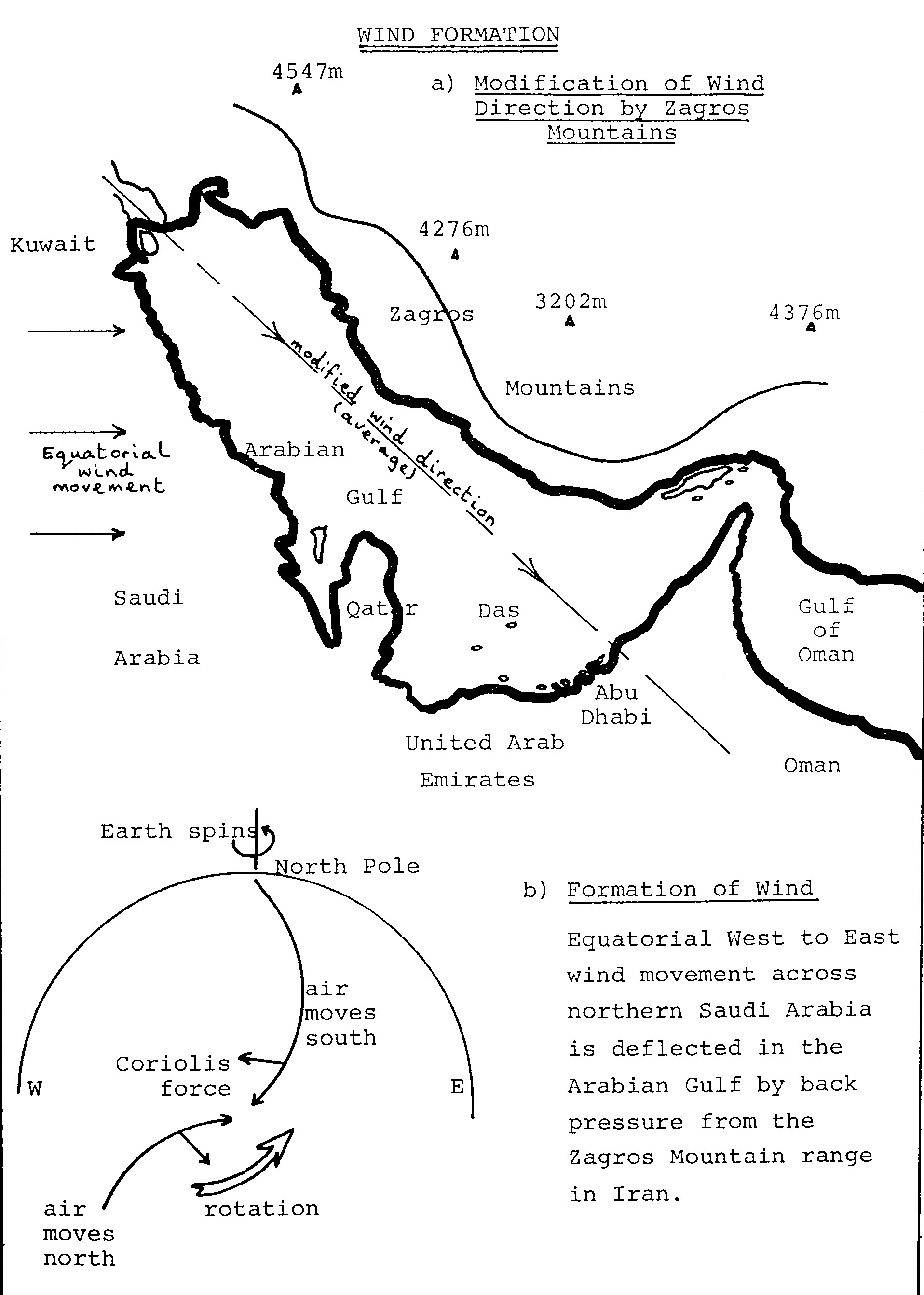
The reverse occurs when the wind is blowing from the opposite direction, as it does occasionally. Figure 3 indicates how wind forms and blows across the Gulf. The predominant wind travels from the northwest, the original westerly wind having been deflected off the Zagros Mountain range in Iran. Average wind speed is about 9 knots with sustained (several days) average maximums of around 30 knots. Of course local seasonal changes occur due to many factors, causing fluctuating wind speeds and direction, but in general the above figures are correct. Strong winds ("shamals") cause large breakers to come inshore and occasionally destroy frail coral and shellfish life.
Gulf Topography and the Effects of Tides on Water MovementFigure 4 indicates the topographical features of the Arabian Gulf, Strait of Hormuz and Gulf of Oman.
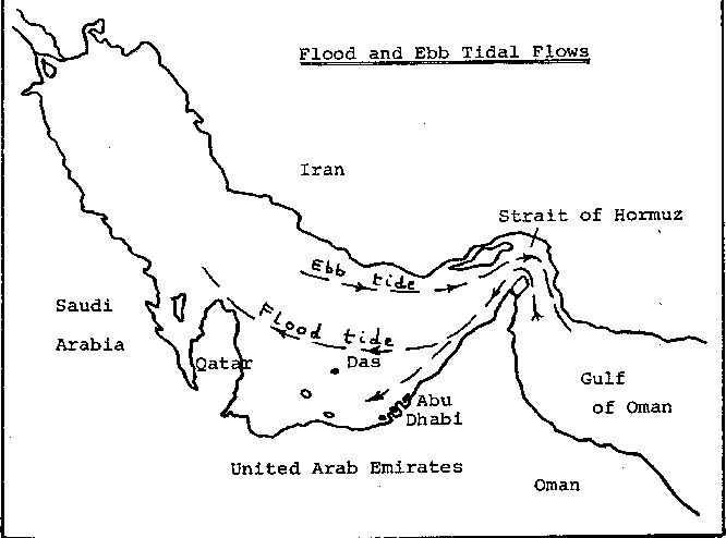
A flood tide, entering from the Gulf of Oman through the Strait of Hormuz, rides high on the surface of the more saline Arabian Gulf waters. lt travels at a speed of up to 0.7 metres per second and so does not get very far before the tide reverses direction. Hence the mixing effect of the two seas is restricted. However, as there is a continuous flow into the Gulf (replacing evaporation loss), the mixing effect tends to be extended. Further research is required to enable the full extent of this mixing effect to be established.
During an ebb tide the outgoing water, being slightly more saline than that still in the Strait of Hormuz, tends to travel deep. Topographical features force the ebb tide to travel close to the Iranian coast where water depth is at its maximum. Figure 5 indicates the flood and ebb tidal flows.
The bottle-neck effect of the Strait of Hormuz causes two things to happen. First, it restricts and channels water flow. Second, the particular profile of the Strait, plus its islands, tend to deflect a flood tide towards the Omani coast. An ebb tide does not react in the same way because it is already moving mainly in deeper water close to the Iranian coast.
When considering water movement inside the Arabian Gulf, the effects of flood and ebb tides can be thought of as energy pulses of approximately 12 hours duration each: pushing and pulling the water already inside the Gulf. This mass of water is also subject to the gravitational effect of the sun and moon, though this is relatively limited because of the small size of the Gulf. Finally, the oscillatory effect (water rushing back and forth rather as in a bath tub) which is maintained by the tidal energy pulses leads to the establishment of a Gulf tidal patterns.
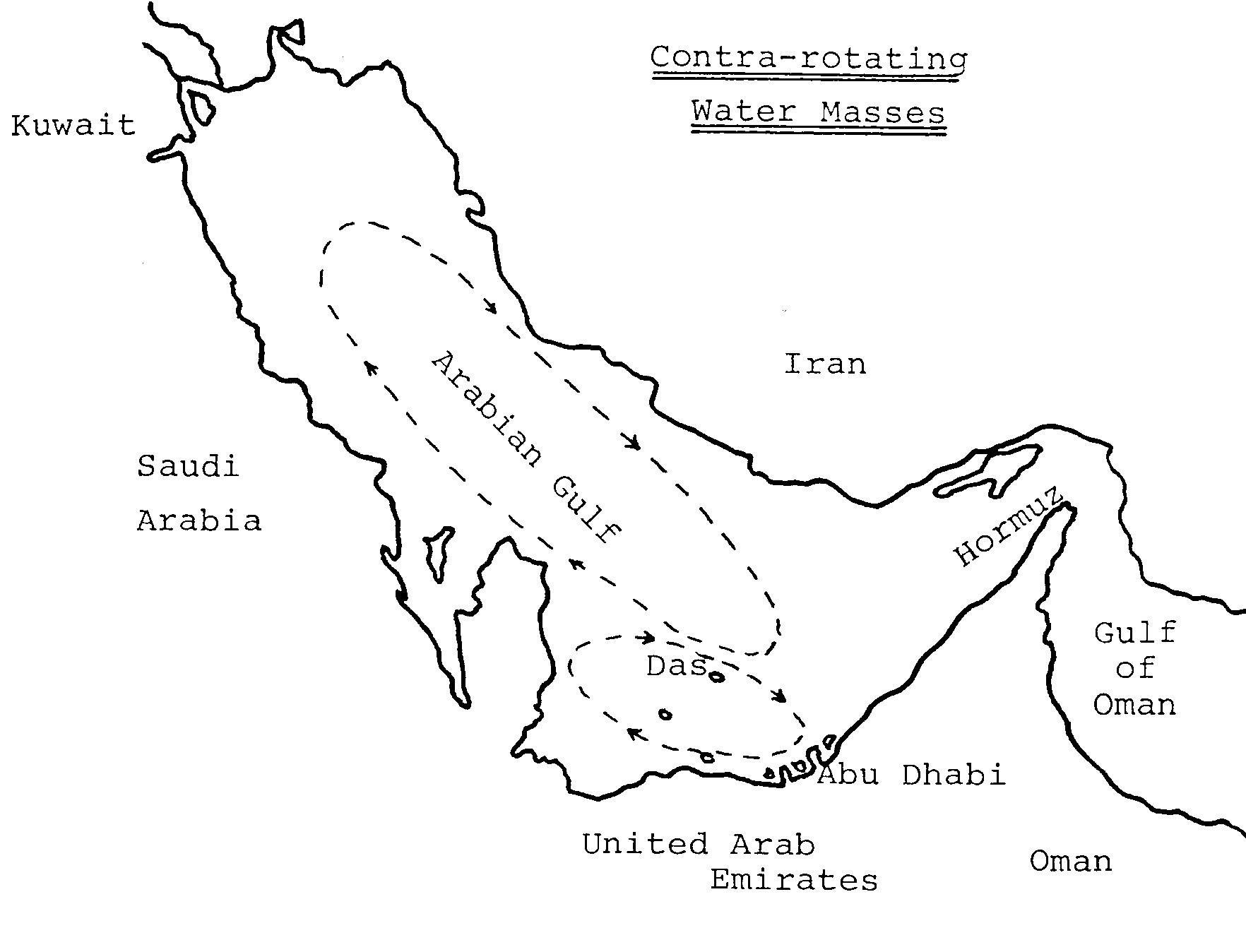
Rotating Water Mass TheorySimply stated, this is two clockwise-rotating water masses, one in the central Gulf area and the other in the Abu Dhabi - Qatar - Das basin. Figure 6 indicates where these rotating water masses are thought to be.
A flood tide is driven towards the Omani coast where its effect is to push water down towards Abu Dhabi and beyond to the Qatar peninsula. A whirlpool movement is created because of the shape of this basin, the water tending to move clockwise. Some of the flow passes on beyond Qatar and indeed some bypasses the basin completely.
An ebb tide travels deep and close to the Iranian coast. This, together with the flood tide having travelled on the opposite side of the Gulf, leads to a clockwise movement in the central part of the Gulf. The border at which these two water masses meet is thought to be very close to Das Island due to the topography of the seabed in that region. Validity of the rotating water mass theory rests on the proof of two concepts:
- A flood tide travels close to the Omani/UAE coast, and
- An ebb tide travels close to the Iranian coast.

Projects
Three special marine projects have been planned, with another under consideration, to be completed over the twelve months to June 1987. These projects are all specifically concerned with seawater within the Arabian Gulf and with UAE weather patterns.
Water SalinityA study of the salinity and specific gravity of Gulf offshore sea water, with a view to establishing areas of higher SG surrounded by less dense water has already commenced. If they are identified such areas may help to support the dual circulating water mass theory. A chart indicating results from the samples will be drawn and be kept for reference in the ENHG Workroom. Initially samples will be from UAE waters but it is hoped to acquire data of the waters around Qatar too.
Water Current Flow Within the Arabian Gulf ,This project involves the close study of a number of scientific books and papers to try to draw a map showing sea water current velocities. Initially the study will be restricted to currents within the Abu Dhabi/Qatar/Das basin. This is essentially a "dry" project, with most of the work being carried out in the workroom.
One piece of useful information is already at hand. Das Island harbour masters have been known to carry out spot checks on tidal currents when vessels are about to enter or leave their berths. It has been found by experience that the currents around Das are rarely as predicted. Such a situation, in the light of the rotation theory, would exist if the two opposing rotational currents tend to cancel out each other, resulting in erratic eddies.
PlanktonThe Arabian Gulf is rich in many forms of planktonic life forms. This project will identify and photograph as many of these as is feasible. For specific research, many samples will be required from points around the Gulf and also the Gulf of Oman (UAE east coast).
Weather Station IThe ENHG (Abu Dhabi) has been acquiring weather monitoring equipment and the possibility of setting up a small station on Abu Dhabi Island (perhaps at the old fort) is under consideration.
References and Notes
- Biotopes of the Arabian Gulf; ARAMCO, Saudi Arabia.
- Obtained from data recorded by Ocean Routes Emirates (Abu Dhabi), previously IMCOS Marine.
- Handbook of the Weather in the Gulf - Surface Wind Data (IMCOS Marine, London)
- Tidal Predictions 1986 (ADMA-OPCO, Abu Dhabi).