Bulletin 32 - July 1987: Understanding Meteorology in the U.A.E. - Part II
Understanding Meteorology in the U.A.E. - Part II
The Low-Level Jet and the 40-Day Shamal
by Andy BestThe Shamal, from the Arabic word for 'north', is a wind which blows with persistence during the summer from late May to early July over Iraq and the Arabian Gulf.
Essentially, the Shamal is an event which occurs as a result of the Arabian Gulf being influenced by a part of the Monsoon circulation where the heat low over Pakistan and Afghanistan forms a secondary low pressure center to the south of the Zagros Mountains in Iran, an effect known as a lee-low. (fig.1)

The cyclonic (anti-clockwise) circulation around the Low pressure center combines with the anti-cyclonic (clockwise) circulation around the semi-permanent High pressure cell over northern Saudi Arabia to create an enhancement of the winds over the Arabian Gulf. These winds are normally confined to that layer of the atmosphere from the surface up to 5000 ft. At ground level during the daytime, the Shamal is particularly strong - it causes dust storms and widespread areas of lifted sand over southern Iraq and Kuwait, but its strength falls off at the surface overnight.
The dust generated in the northern Gulf is lifted and carried southeastwards to affect Bahrain, the Qatar peninsula and quite frequently the UAE. During the summer months, dust haze is a serious inconvenience and is often a hazard to aviation operations. To be able to forecast such events, we must look to the dust bowl of Iraq (more specifically the Tigris-Euphrates flood basin) and consider the trajectories such dust bands take.
The fine particles in the Iraqi basin are lifted into the atmosphere by strong surface heating (fig.2). Temperatures up to 50 degrees Celsius in high summer develop a Thermal Low here that reinforces the seasonal lee-low of the Zagros Mountains; these convective dust clouds and fine sand particles are then carried southeastwards by the strong flow.
It is logical now to introduce the low level jet that is a major factor in contributing to the persistence of the Shamal. The jet is mainly a thermal phenomenon, and is confined to heights below 5000 ft. where the vertical temperature profile forms an inversion (fig.3).

The inversion delineates a sharp change in temperature. Normally the temperature decreases with height at a rate of about 9.8 degrees per km or just over 3 degrees per 1000 ft. However, during the hours of darkness the surface heating is cut off, the lower layers of the atmosphere rapidly cool and there is a sharp kink on the vertical temperature profile. This inversion is a common feature in very hot countries like the Middle East where there is a large day/night temperature difference. During the daytime, under strong surface heating the low levels of the atmosphere are thoroughly mixed and surface friction effects limit the speed of the wind here. However, during the night when the heat is cut off, the lower levels become stable, very little mixing occurs and the low-level wind flow becomes quite smooth. It is then that the inversion occurs to affect the flow (fig. 4).
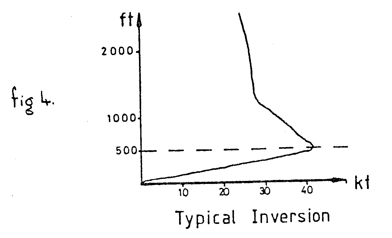
Maximum temperature inversions are around 9 degrees Celsius per 500 ft, i.e. 25 degrees at the surface and 34 degrees at 500 ft. above. The low level jet is a physical consequence of marked temperature differences and tends to ride on top of this sharp inversion. It has a speed of about 42 - 48 knots at 500 ft (fig.5). During a Shamal the strong winds add to the low level jet and cause an increase in its strength. The actual mechanisms are slightly more complex but this explanation will suffice for now.

The strong Shamal winds add to the low level jet caused by the inversion, and wind shear becomes a problem, particularly with respect to aircraft movements. As the aircraft descends, any instantaneous increase/decrease in the headwind produces an increase/decrease in the lift of the plane. Such wind profiles can also create problems for aircraft on climbout - especially with such strong inversions that originate at the surface as invariably there are light winds near the runway maybe from the southeast which, as the aircraft climbs, rapidly change to this 40 to 50 knot northwesterly; if this last is not forecast, the pilot could be led into a false sense of security.
The so-called "40 day Shamal" brings with it quite significant visibility reductions over the western parts of the UAE. Most of the Eastern Emirates escape this as the wind funnels the dust and sand into the Empty Quarter. There are occasions, though, when the High Cell over Saudi Arabia and the Zagros Lee Low extends over a majority of the UAE and dust haze is brought over the entire region for a short time. When the cells migrate back to their normal positions the winds rapidly decrease; then the haze remains in situ and the strong thermal heating causes it to linger in a blanket over the country for days at a time, with visibilities remaining at around 5000 to 3000 m for most of the time, reducing to below 1500 m on occasions. At night the inversion acts as a cap to the dust haze and restricts its movement in the vertical. (This is noticeable in Abu Dhabi on most mornings when smoke plumes and the Umm an Nar refinery flare rise and hit the inversion and are forced to spread out underneath it).
Although Shamals provide good, persistent winds for wind surfing and yachting, the disruptions they cause in terms of the economy are considerable. With such constant winds over the Arabian Gulf the waves reach heights in excess of 10 - 12 ft at times and winds near the surface can be a constant 30 - 35 knots. Oil industry operations are frequently affected by the Shamal and helicopter movements are disrupted as well as the local fishing industry. Compensation for loss of revenue must run into hundreds of thousands of Dirhams each year, hence it is important for weather forecasters to be able to predict such Shamal events to cause minimum disruption to industry and give adequate warning to the harbor authorities and the media as to the onset of the Shamals.
Reference:D.A. Membury (1983) Low Level Wind Profiles during the Gulf Shamal. WEATHER, vol.38 no.1