Bulletin 10 - March 1980: A Lost City
A Lost City
By John D. MacRaeIn a bookshop in Stirling, Scotland, I obtained a second-hand copy of a book called "The Sand Kings of Oman" by O'Shea published in 1947. It describes his experiences while based at Sharjah Fort during his career as an RAF officer in 1944. Chapter 17 describes an incident when a colleague flies off course and sights ruins of a town in the Empty quarter -- Rubh al Khali, and how O'Shea proceeds on an expedition to locate it.
During my recent visit to the Emirates, I decided to determine how accurate was the information recorded in this chapter, and in so doing, learnt that what I thought was a little known book had been read by certain knowledgeable people who claimed it to be fictitious. One person considering that all O'Shea had done was to have talked to local people, read appropriate publications and concocted the expedition.
This not only made me more anxious to prove whether he had or had not, but time was not on my side and in what follows I am asking the assistance of members of the Emirates Natural History Group to read the text and hopefully provide answers to the questions I have raised.
Extracts from Chapter 17 of "The Sand Kings of Oman"
In December 1944 an RAF pilot flying a Lodestar aircraft between Salalah, in Dhufar, and Muscat, went a long way off his course and made a forced landing in Sharjah. It was rumored(1) that he had crossed the eastern section of the Rub al Khali desert and had noticed several interesting things on the ground, including the wreckage of several aircraft, one of them ostensibly Italian. For many years I had been interested in the Great South Desert, as Major Cheeseman called it in his book "In Unknown Arabia", and had read of its loneliness and vast extent in St. John Philby's "The Empty Quarter" (2) , and Mr. Bertram Thomas's "Alarms and Excursions". These fine books, together with Burton's translation of the "Arabian Nights", Doughty's "Arabia Deserta", and Lawrence's "Seven Pillars of Wisdom", transported me in fancy from the easy chair of my London flat to the burning sands of the desert, but never in my wildest dreams did I imagine that I should ever stand on the threshold of the unexplored Rub al Khali.In parenthesis, I think few people realize that it was one of Colonel Lawrence's ambitions to visit the Rub al Khali. I first met Lawrence through a journalist friend in a Chancery Lane flat, and visited him several times at Cloud's Hill Cottage. The conversation was invariably about Arabia, and Lawrence was intensely interested in the legend of a "lost city" which was said to exist in the middle of the Rub al Khali.
"I am convinced that the remains of an ancient Arab civilization are to be found in that desert," he once told me. "I have been told by the Arabs that the ruined castles of the great King 'Ad, son of Kin'ad, have been seen by wandering tribes in the region of Wabat. There is always some substance in these Arab tales."
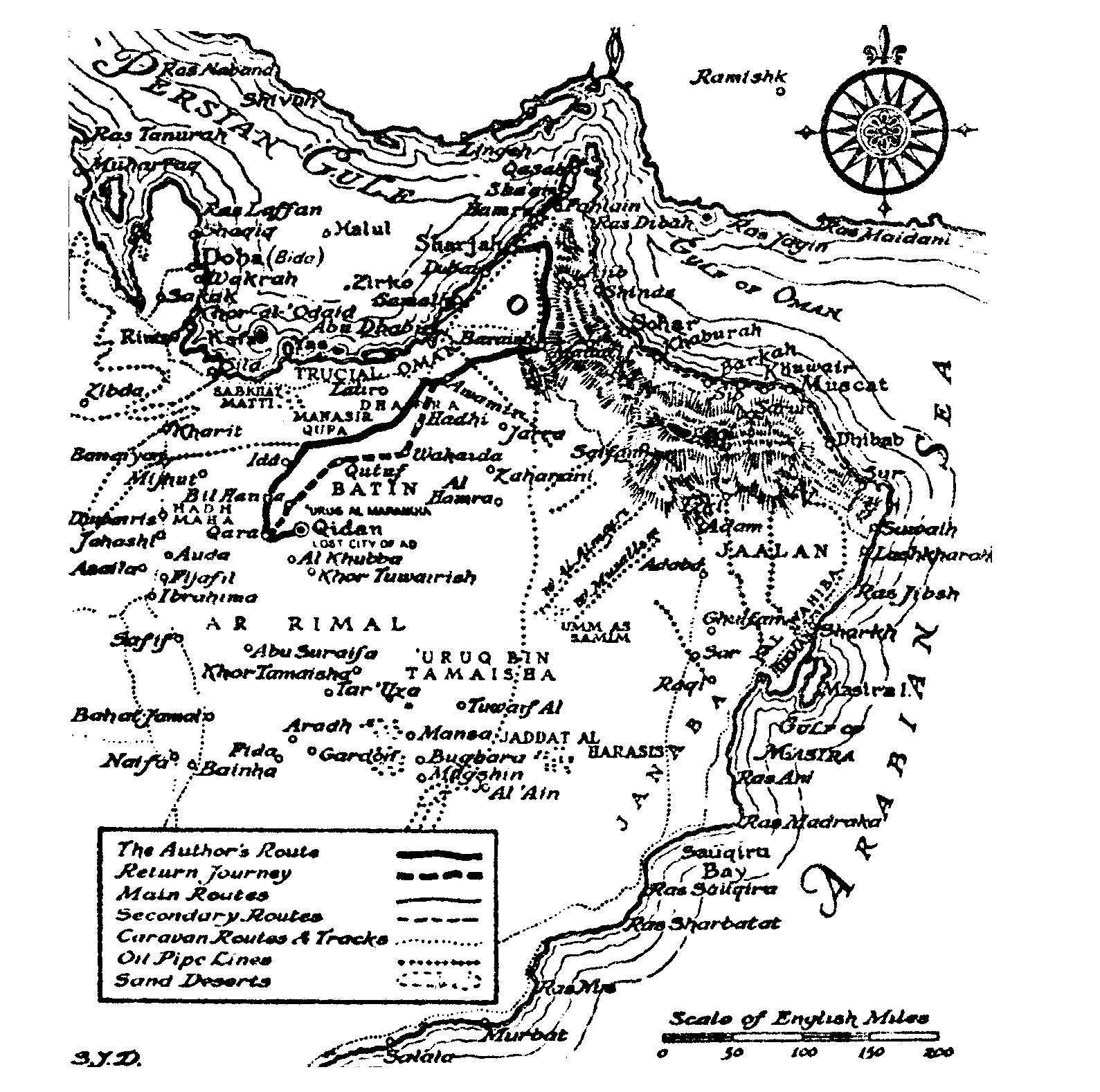
I was fortunate in meeting this pilot who had made the flight, and in the mess one night he gave me an interesting account of his trip across the desert from Salalah to Sharjah, a distance of nearly 600 miles. On an Air Ministry map he traced the route he had approximately flown and excited my interest by pointing out a region Al Maharadh where, he said, he had noticed what appeared to be a small town. On descending to 500 feet, he observed that the buildings were all ruins, and included several fort-like structures. They were situated on a hill rising steeply out of the desert which he estimated to be about 500 feet above sea level. Before I left him, we worked out the position of these ruins, which lie about 20 miles south of the Liwa desert and between 22° and 24° longitude and 52° and 54° latitude.(3)
My 14 days' leave fell due at the end of the month and I was determined to spend it on a visit to the Rub al Khali and, if circumstances were favorable, in searching for the ruins of this city. Lt. Schultz, who had accompanied me on my trip to Buraimi, was extremely eager to go with me when he heard of the project; by good fortune his local leave fell due at the same time and he was able to persuade his commanding officer, Major Raimer, to lend him a four-wheeled-drive truck for the journey.
Realizing that the British authorities would not give me their blessing for the excursion, we kept our destination a close secret and even the members of my staff at the Fort were not aware that I intended to penetrate the Rub al Khali. As it happened, the Political Officer, Captain Tandy, had just been posted to Kuwait and, as his successor, Captain Murphy, had not yet arrived from Bahrain, there was no one at the Residency whom I could officially inform of my intended visit, Jasim bin Muhammed Kadhawi, the Agent, being away on official business, also.(4)
Some difficulty was experienced in obtaining guides; two of my Askhari guards, Khofan bin Salim and Muhammed bin Hadi, who were fearless fighters with the scars of battle on their bodies, agreed to accompany us, and Suliman Beg, our Sindhi driver-mechanic, who was a Mohammedan, said he would come and by my cook-bearer and bottle-washer combined. None of these three knew the desert beyond Buraimi, however, and it was foolish to attempt the journey without guides. A few days before we were due to start the Sheikh of Al Ajman came to our rescue by offering to lend us one of his best trackers, a man of the Manasir tribe, who had been into the Rub al Khali several times. To these four were presently added a guide named Hamid bin Rahman, of the Ghafran section of the Murra tribe, two Bedouin guards from the Sheikh's personal "army", and Abdulla, an ex-slave who would perform the menial tasks. (5) Then Sheikh Rashid produced his trump card by offering to lend us a dozen of his best camels, since he was convinced that we could not make the journey by car.
In the end, we decided to take the truck as far as Nimairiyah(6) , 50 miles west of Buraimi, on the main caravan route to Qatar, and proceed thence by camel, taking an additional driver who could return to Sharjah and meet us again at Nimairiyah in 10 days' time.
On April 10 1945 we made our final arrangements, packed out tents and baggage and set out for Buraimi on the following day. Accompanying Schultz and I in the truck were Suliman Beg, Khofan bin Salim and Muhammed bin Hadi, our Askharis; the guides, trackers and other members of Sheikh Rashid's party had left with the camels two days previously and were to meet us at Nimairiyah.
The journey to Buraimi which I had previously visited was without incident and after a brief rest in the oasis for refreshment, we continued along the rough caravan route until the village of Bahairan, south of Wadi Talaif(7) , was reached just before sunset. There were several good wells in the district, so we were able to replenish our water bottles. The town appeared to be deserted, except for an encampment of Bedouins who did not, however, approach us; we decided to push on a little further and spend the night in the desert.
At dawn, we once again set out after a quick breakfast and followed what we thought was the caravan route; after a few miles the track disappeared in a shallow wadi full of boulders and shrubs and, on taking our bearings, we found we were several miles off our course. After a delay of two hours, we found the route once more and reached Nimairiyah shortly after 10 o'clock. The caravan was waiting by one of the wells and Hamid bin Rahman, the Murra guide, greeted us with enthusiasm.
During the process of transferring our equipment from the car to the baggage camels, we had our lunch and took some photographs of Nimairiyah, a typical Arab settlement built(8) around a small oasis and a date garden. Leaving the caravan route on our right, we cantered over the desert in the direction of Latir(9) , the site of a disused well.
After five hours of fairly comfortable travel, we reached the district known as Dhafra, which is composed of flat, waterless desert relieved by occasional dunes and patches of anlab grass. We stopped here to allow the camels to graze and pitched our tents under the shoulder of a sand hill. We estimated that we were approximately 100 miles southwest of Buraimi and east of the Manasir desert.
The next day, we continued southwards through the Liwa region to Idd(10) where we were fortunate to find an old well with water at 10 fathoms. It lay in a bush-covered hollow of the dunes and the cameleers set to with a will to open up the shaft which had fallen in.(11)
We had made good progress so far and were four days out from Sharjah; although it was early afternoon when we reached Idd, the weather was hot and humid, the barometer registering 90°F. There was no point in tiring either the camels or ourselves, so we decided to encamp here for the night. The Arabs lay down under their tents and went to sleep while Schultz and I explored the neighborhood. As far as the eye could see, the desert was bare of vegetation, with occasional dunes and ridges of hard sand and limestone conglomerate. In the distance, by the aid of our glasses, we could see the dim outlines of a peak or a large hillock which we estimated to be 50 miles due south of our camp.
The desert sloped gently away from Idd towards an unbroken steppe, littered with the outcrops of volcanic rock and sandstone boulders. Two miles away we were surprised to find a shallow depression, about 200 yards long, with pink sandstone walls rising to 50 feet in places. These cliffs were studded with tiny fossil shells, similar to the mollusk I had picked up on Sharjah beach(12) . The skeleton of an ibex, still covered in its skin, lay in the sand beside a dead abal bush. The creature had evidently died from starvation. Of other forms of animal life there were no signs, and we did not even see an insect in this pit of death; on our way back to the camp, however, Schultz spotted a fork-tailed lark which, according to Mr. Philby, is one of the few birds which inhabit the interior of the Rub al Khali.
Ahmed bin Aziz, one of the guide, greeted us with some excitement when we got back to the camp and said he had seen a bustard (houbari) flying overhead; he had fired at it but it was too high to hit. Neither Schultz nor myself had heard a shot, which we supposed was due to the curious formation of the dunes, which had a trick of muffling sound. We had heard that there were so-called "singing sands" in this region, which gave forth a booming sound, but the guides were unable to give us any information concerning this. In the camp, we found a small mantis and two red spikers but, owing to the scarcity of vegetation, there was scarcely any animal life here.
We continued our journey the next day in a southerly direction, leaving on our left the site of an old Bedouin encampment known as Umm al 'Amad(13) , which has a hillock and a single samar tree but no wells that we could see. This region the Arabs cal Al Maharadh(14) . The sands were covered with curious round pebbles and black stones, some of them sharp enough to cut the camels' feet so that two of the beasts had to be bound. The going was very rough and we made slow progress, the distance for that day not exceeding 25 miles. There was no herbage for the camels to eat so we had to feed them on the rations which Hamid had wisely provided for such a contingency. Our own supplies were running fairly low, and Schultz and I gave up the luxury of shaving and rationed ourselves to a pint of water each a day, which we supplemented with camels' milk.
Ten miles ahead we encountered a series of high sand ridges which made our progress even more cumbrous and in the valleys between these dunes the sand was often dangerously soft and deep. I thought of the moving sands at Dahna which Wrede, the explorer, had encountered over a century ago and wondered whether these contained similar pitfalls. We decided not to go ahead but to take a course due southeast in the direction of Qara(15) . By so doing we were able to ride on the crest of the dunes, which run in a northwesterly curve, and avoid the dangerous sinking sands.
In was as well that we did so for we were told later by a party of Bedouins whom we encountered on the return journey, that these sands got worse and worse towards the western desert and have swallowed up whole caravans of camels. We were fortunate from another point of view. When about 10 miles from Qara, Abdulla, the ex-slave, who was walking beside the leading camel, suddenly gave a great shout. He pointed towards the shimmering horizon and, shading our eyes, we could just see the flat summit of a large hill which seemed to rise steeply out of the desert. It was one of those curious rock formations one sometimes sees in the Rub al Khali and we decided to ride towards it. From the summit we might obtain a good view of our surroundings for we had lost our bearings and were not quite sure whether Qara lay behind or ahead of us.
At four o'clock in the afternoon, after a hard gallop across the sands, we reached the slopes of the hill, which was about 500 feet above sand level. The summit, which I estimated was 1000 yards long, was as flat as a billiard table and the crumbling sandstone cliffs were precipitous and slippery. The camels were left grazing on some harm bushes at the foot of the hill while Schultz, Hamid and I climbed the rock, reaching the summit after a stiff climb. It was not quite as flat on top as we had imagined. The sides were smooth and covered with a layer of sand, but in the center there was a large bowl-shaped depression with gently-sloping sides. The slopes were profuse with vegetation, including stunted gharf and samr bushes, and a short, dry grass with razor-like edges. What took our breath away, however, was the sight of a derelict town at the base of this bowl.(16)
The buildings covered about two acres and were surrounded by a low wall of crumbled sandstone blocks which at one time had been much higher. Most of the buildings were a mass of rubble, so that it was difficult to distinguish houses or streets, but two of the towers were still standing; these measured 30 feet in circumference and 40 feet high. The tops were not crenellated like the fort towers of Oman, but smooth and unembellished, with small lookouts through which one had a good view of the surrounding desert. The walls themselves were in places four fee thick, the stone blocks -- the largest of which measured two feet in length and 18 inches in width -- being held together by a rough mortar made of gypsum and clay.
Being neither archaeologists nor historians, we could not conjecture the age or the probably origins of this strange town on the hilltop. None of our Arabs had heard of it before and it is not near any of the caravan routes or Bedouin encampments. Small lakes of water lay at the flat end of the bowl, suggesting that there is no lack of moisture during the rainy season; this could explain the abundance of vegetation we found growing there. One curious feature of the ruins were the large circular stone discs, the size of a cartwheel, with a hole in the center with rays, roughly hewn with some blunt instrument, extending like spokes to the rim. These discs were composed of a hard white limestone and were about four inches in thickness across the rim. Hamid also found a piece of broken black pottery, with a high glaze, which I took back with me and presented to the Sheikh of Al Ajman.
Was this, I wondered, the "lost city" of the Rub al Khali, whose whereabouts has for centuries been a theme of fascinating speculation among explorers and travelers? If it were not the fabled seat of the legendary King 'Ad, then perhaps it was the seat of a lost tribe which had wandered across the desert and made its home far from the haunts of men on the top of an isolated hill.
The truth we may never know but any archaeologist who wishes to follow in our footsteps and find this city for himself will doubtless be able to estimate its approximate age and reconstruct the plan of its buildings; excavation may even yield the secret of its origin and bring to light evidence of the tribe which built it in the dim past.(17)
In the morning, when the haze had lifted, we had a closer view of the desert from the summit, and Schultz, looking through his field glasses, observed a clump of trees which he thought might be Qara. This indeed it turned out to be, Qara lying 10 miles due west of the ruins. We set out on the return journey soon after breakfast, feeling refreshed and energetic and, turning due north, passed through Bil Hanna(18) on our way to Umm al 'Amad. Here we came upon our old tracks and the next day branched north to Qutuf, a distance of 30 miles, leaving Idd 10 miles to the north.
The journey back was uneventful; the desert was much firmer and less rocky than had been our previous route and, the camels being able to travel at a good pace, we reached Wahaida(19) on the third day; here we found a well, with brackish water at 12 fathoms. Schultz shot a bustard which was feeding in some scrub and we roasted it for our evening meal. The journey north to Nimairiyah occupied two days, the route passing through Hadhi, where we found two disused well; the 35 miles between Hadhi and Nimairiyah were desolate in the extreme, without a sign of water or vegetation, and we were exhausted and parched by the time we reached Nimairiyah, on the fifth day after leaving Qara.(20)
Nimairiyah was reached at five o'clock in the afternoon and there was no sign of the car. We spent the night in an encampment of Bedouins who were amazed to hear that we had been as far west as the Al Maharadh country which, they said, is wild and dangerous.
The memory of this expedition will remain with me for the rest of my life; it was the only form of exploration I have ever been able to undertake, and I could be well satisfied with the result. Had I been accompanied by an archaeologist, or been equipped with tools and scientific instruments, there is no doubt that my discovery would have been a much more valuable record than it actually is. Unfortunately, I was pressed for time and was unable to undertake any kind of excavation. Had one the opportunity to revisit Arabia and form an expedition composed of experts, I have no doubt that the ruins of Qara would yield surprising secrets to the world.(21)
Endnotes
-
It is interesting to note that the word "rumored" is used and
that the author had ambitions to enter the Rub al Khali. Return
to text.
Mr. St. John Philby has also made mention of a "lost city" in
his book, "The Empty Quarter" and Bertram Thomas describes a
conversation he had in page 16 of his book "Arabia Felix", published
in 1938, which relates the tale of the lost city. Extracts are given as an
appendix to this article. Return to text.
The map reference he gives covers some 22,032 square kilometers yet he
continues to state that the ruins lie 20 miles south of the Liwa. The pieces of
information are not compatible with each other. Return to
text.
He clearly takes pains to describe the absence of anybody in authority
who would be able to collaborate that he undertook the journey. Return
to text.
It would be interesting to receive information on the relationships of
the tribes at this time. For it was usually necessary to have as a member of a
party a guide from the tribal territories through which it was intended to
pass. Return to text.
Nimairiyah is shown on recent maps as Tawi Numayriyah. Of interest is
the mention of the route to Qatar voyaging across the desert rather than via
the coast. On the map for the book "Arabian Sands" by Thesiger
(published 1959) a track is shown from Buraimi to Raqaib in the direction of
Qatar. The track would seem to pass through the region of Numairiyah. Return to text.
Wadi Talaif I have been unable to trace on a map but Bahairan I
consider is now recorded as Niqyan bil Khayran.Return to
text.
The use of the word "built" seems strange in what he
describes as a typical Arab settlement. It conjectures perhaps a miniature
Buraimi Oasis with walls and gardens, yet this seems out of character with the
area. I would have thought that if it was such an established place then it
would be better known today. Recent maps indicate that it is only a well. Return to text.
Latis is one of the villages in the Liwa. He does not in fact visit it
but states he is heading in that direction. Return to text.
Idd is a well established village in the Liwa. Return
to text.
It has been argued that: Return to text.
A well at 10 fathoms (60ft) was not possible in the Liwa in 1945 and
would collapse. It had. Return to text.
Why use a disused well when in that part of the Liwa plenty of open
wells existed. Return to text.
It is not possible, even with glasses, to distinguish a peak or hillock
50 miles away in this area. Also the phenomenon of a mirage should not be ruled
out, as this has the effect of making distances deceptive. Perhaps some person
with knowledge of the wells in the Liwa and clarity of the atmosphere in April
could comment on the reliability of the information in the text. Return to text.
A geologist would perhaps care to comment on this likelihood of the
accuracy of the surface features described in this and previous paragraphs. Return to text.
Umm al Amad is shown south of Aradah in a map of W. Thesiger's journey. Return to text.
Al Maharadh region could be the area around the place Aradah southwest
of Idd. Return to text.
Al Qarah is in Saudi Arabia. A place, Al Qarra, is recorded on the map
issued by the Geographical Journal Jan-March 1948, which illustrates the routes
of W. Thesiger and is shown 40 miles south of Aradah. Al Qarah is also shown on
a 1968 map of the area as being 140 miles southeast of Aradah. In O'Shea's own
map, his distance agrees with that of Thesiger. Who is correct, or are there
two Al Qara's? Return to text.
It seems feasible that such a location could go unnoticed until the
advent of air flight. Also today, 35 years later, if the town exists how much
of that depression is filled with sand, covering the ruins completely,
therefore going unnoticed by aerial photography. Yet, on the other hand, it
could be pure imagination. Return to text.
Here is a request asking for a professional to collaborate his journey.
This was made when the book was published, not long after the journey. If it
was a fictitious journey, why risk the ridicule that would follow any such
exposure. Return to text.
Bil Hanna has been located on Thesiger's map, southeast of Umm al
Ahmad.
- Wahaida could be the area in the Liwa between Qutuf and Nafir shown on the map as Wahaydah. Yet this is a very short distance for one day's journey and does not agree with the location on O'Shea's map. Return to text.
- It is interesting to note that W. Thesiger was cautious of entering the Liwa some 14 months later than O'Shea, as it belonged to the Albu Falah of Abu Dhabi who were said to be fighting Said bin Maktum of Dubai. (Arabian Sands, p 137)
- Nowhere in the text is the name of the lost city written, yet on the map he shows it as Gidan, "The lost city of Ad." Interestingly enough on a map published in 1968 a place lying approximately 100 miles east of Al Garah is named Qalamat Hamarir al Kidan.