Bulletin 33 - November 1987: The Wahiba Sand Sea, Oman
The Wahiba Sand Sea, Oman
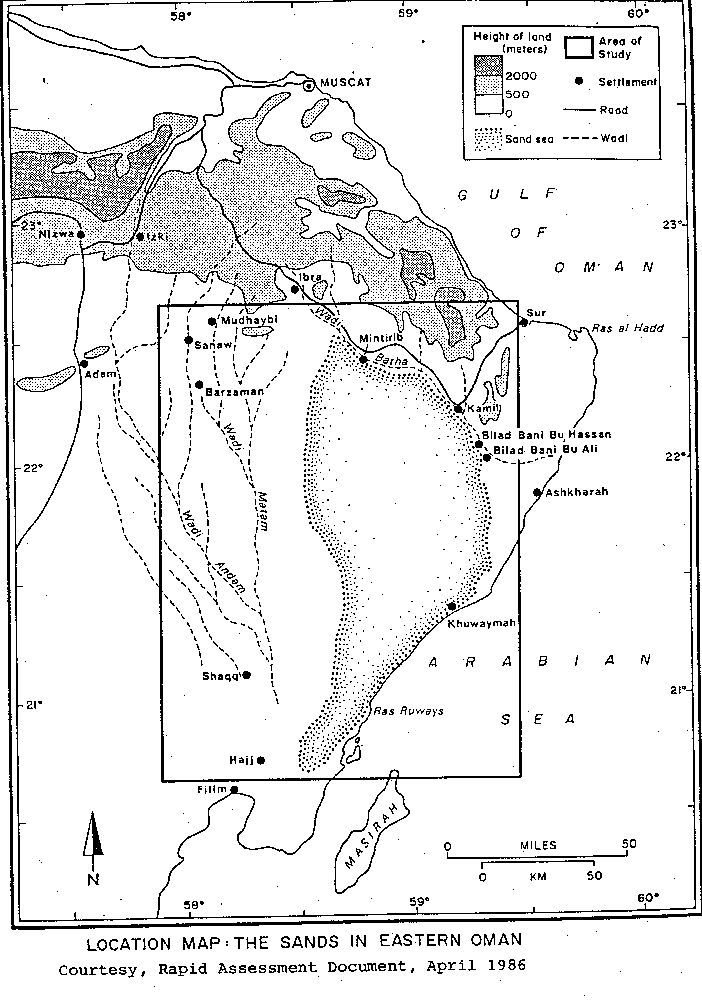
Royal Geographical Society Symposium, October 7th1987
By Rob WesternIntroduction
The Royal Geographical Society Wahiba Sands Project of 1985/86 was an intensive survey of specific aspects of the area involving scientists and researchers from both UK and Oman. The primary scientific aim was to study the early development of the Sands, its ecosystem and the impact of recent change. Five objectives were identified:
- Sedimentary and geomorphologic history;
- Sand movement, moisture and vegetation;
- Biological resources and range management;
- Indigenous communities and their inter-relationships;
- Oil wealth and development.
An earlier symposium was presented at Sultan Qaboos University in Muscat in April 1987. Some of the studies are continuing, but preliminary reports have been published. It is hoped that the main report will be published in 1988, on the lines of previous Journals of Oman Special Studies.
Although the Omani Government had already conducted some research into the area and its people, it was recognized that a unique ecosystem was being threatened by political and physical forces as a result of the rapid modernization of the country in recent years. By researching the Wahiba Sands from as many scientific viewpoints as possible, it is hoped that the recommendations, if implemented, will enable the region to avoid most of the worst excesses of the encroachment of modern market forces, and enable its people and economy to maintain its special equilibrium in relation to surrounding areas of Oman.
The Omani Government and local companies took great interest form the start, while the people living in and around the Sands were open and helpful towards the Survey aims. It was, in effect, a joint project because of Oman’s awareness of its responsibility towards management of the area.
The fieldwork programme comprised a mapping phase in January and February 1985, various site studies between December 1985 and April 1986 and a final phase in 1986/87 to make comparative studies at different seasons and under different climatic conditions.
The following notes briefly outline the results given at he London Symposium on October 7th, 1987.
Overview
The Wahiba Sands Survey comprises an inventory of a sand sea in a time of impending change and pressure. The Wahiba Sands are isolated and bounded by sea and mountains, and therefore make a good subject for study. It is divided into distinct units:
- Terrain that can be classified as high, low and peripheral sand seas.
- On the higher dunes vegetation cover is approximately 5% to 25%, but further south, on the lower, more mobile dunes, it is typically 5% to 15%.
- The peripheral sands are thin and discontinuous, and include much-exposed aeolianite (cemented sand) and gravels.
- The high dunes are separated by swales (valleys) one to three kilometers wide.
The Quaternary History
Dr. Rita Gardner then described the patterns of palaeoenvironmental change and associated human activity in the Quaternary and, briefly, the Holocene. An analysis of palaeo-channels indicated climatic changes, while an examination of lithic remains gave some pointers towards a chronological framework. Field investigations revealed a seven-stage sequence of Quaternary deposition, indicating prolonged aridity until a wetter phase probably in the recent Holocene. The underlying and in some places exposed older aeolinite is the most extensive so far reported anywhere in the world. Normally aeolianites are close t coastlines, but here in Oman they extend to over 100 kms inland while diving showed that they continue offshore for some 3 kms. Outcrops in the southwest zone suggest a maximum thickness of 50 m. There has been much wind erosion and the residual aeolianite plateau lies some 15-20 m. above modern wadi level. In general the deposits are well cemented, the crust on the sequence being a presumed calcrete some 1.5 m. thick. The degree of lithification increases with depth, probably reflecting the relative period (s) spent under the water table. Terraces in the aeolianite were probably caused by flash flooding and by erosion from a prevailing S to SW wind.
Close to the sea lies a nearshore deposit of pebbles, sands and shell fragments cemented by calcium carbonate. Some deposits may be covered by younger aeolianite, much of which is found a little further inland, on the beach, and offshore. These are weakly cemented and contain two major and several localized unconformities.
The large stable dunes in the interior of the sands overlie the older aeolianite and are assumed to postdate the younger deposits. The reddish color of these dunes is attributed either to iron oxide-coated quartz grains or chert fragments. The linear ridges are 1-3 kms apart and represent the phase of greatest aeolian activity in the history of the Sands.
Various mesa deposits reflect resistance of localized redistribution of carbonates, silts and clays to wind erosion. Some of these flat-topped mesas are up to 40 m. above sea level, the surrounding sands and gravels having been deflated.
Prehistoric occupation (7000-5000 BP) occurs in association with the youngest deposits and appears to coincide with the wettest climatic period. Aceramic lithic sites are common on inter-dune playas, below the coastal mesas and on old land surfaces along crests of the high dunes. The associated industry is bifacial and pressure-flaked with tanged points, i.e. within the bifacial and tradition reported elsewhere from Arabia. The characteristic points are often accompanied by various drills, adzes, scrapers and grinding stones. Because of slight variations the sands collection has been named the Quhayd (after the type site) variant of the Dhofar facies.
Dune Processes and Hazards
Dr. Andrew Warren then introduced the topic of dune movements, based on a detailed examination of three sites in different dune types. The dynamics of dune movement were monitored by means of photogrammetry, observations of pegs and fixed posts, and a limited amount of sand trapping. It was clear that the lower dunes moved daily, even hourly. The two characteristic winds are light winter north easterlies and the strong summer southwesterly monsoons. These later are primarily responsible for moving sand from the coast inland.
Dune sources for the Wahiba Sands were identified as follows:
- River (now wadi) alluvium;
- The river (wadi) mouth;
- The sea, from offshore shelf sand deposits;
- Wind erosion of ancient aeolianites;
- Coastal cliff erosion.
As a gross simplification it may be stated that the low dunes in the south are the first to form, and then a combination of wind and erosion pushes these north to form the linear megadunes of the interior.
Sediment form the Hawasian series rocks, mostly cherts, are dark brown, orange and dark red. Some grains are reddened by age by iron oxide. Ophiolitic materials (possibly from fluvial gravels) have dark, sometimes black, covering. The marine source is supplied by large amounts of shell fragments. Further south the sediments are lighter in color as the dominance of the Hawasina and ophiolitic sources decreases.
Traditional dune control has been by fences (often palm fronds) but research by the team revealed that these may not be correctly sited to be of major benefit. More work needs to be conducted on the relationships between moisture and dune movement, the area of a dune subject to greatest movement and overall speed of movement.
By far the greatest mobility recorded was on the upper flanks of dunes. This was attributed to the fact that this is the area of highest wind velocity, that winds often approach dune ridges obliquely, and that slope erosion is caused by the drag velocity of winds. By contrast there was virtually no sand movement in hollows.
Sand drift was studied at the oases of Badiyah (not to be confused with the village of the same name on the Fujairah coast). A United Nations Environment report of 1982 had asserted that mobile dunes overrun; that grazing was leading to desertification; and that sand movement should be controlled. Significantly, the RGS survey showed that none of these assertions was based on a systematic study and some of the propositions were false. For example, the oases themselves were acting as sand traps, and sand movement seems to be directed in corridors, not along a general front. Also, the presence of surface sand itself does not necessarily mean that this sand is available for movement in the wind. Some surfaces, including some dunes, appear to be quite stable, being protected by coarser sand and vegetation.
Moisture in the Air and in the Ground
Dr. Ewan Anderson then presented an overview of general climatology, with special reference to microclimate, water sources, and the role of Prosopis trees. Mean air temperature recorded at local weather stations (data since 1982) is 18°C in Dec./Jan. rising to 33°/34°C by June. Humidity is more variable, and highest wind-speeds are during the summer months. The team set up its own weather station near the field base to monitor temperature and vapor pressure gradients from ground level to 100 cms. There was a significant difference between temperatures at ground level and one meter, at times up to 4.5C. Ground level moisture contents displayed a diurnal range while those at one meter were fairly constant. At ground level relative humidities were found to be constant. At ground level relative humidities were found to be 60-70% by day and up to 100% by night. Corresponding figures for one meter above ground level were 40-50% and 90%. Rapid cooling leading to condensation and dew formation was marked. Solar heat would seem to penetrate some sands to 20 cm. Moisture content of sample soils was taken following infiltration tests. On one such test, a dune top was saturated to 50 cm. 24 hours later the wetting front had reached 90 cm; there was little evidence of drainage beyond 120 cm and it would appear that excess water moved laterally. In the inter-dune depressions, however, water drained beyond 160 cm for up to 14 days. Generally, bare sands exhibited a slower evaporation rate with subsurface layers remaining wet until late March (after rains at the very beginning of February).
Dew measurements were concentrated in one region near the field base, to monitor data several times daily. A number of techniques were used, including gravimetric plates, electrical sensors and visual methods, since no standard instrument for measuring dew exists. At the dune site, there was an average daily catch of 0.76 g, 0.70 g on the ridge and 0.82 g in the valley. The highest catch for any sensor was 2.12 g on 8th March 1986. The difference between upper and lower site measurements may be due to air turbulence at the dune ridge, which restricts dew settlement.
There was a clear contrast between the sensors under Prosopis trees and on the open sand away from the trees. The mean for the former was 0.13 g and for the latter 0.93 g. The mean for the edge of the Prosopis was 0.24 g and for the interior, among the foliage, 0.06 g. This expected trend is probably due to a number of factors: a combination of warmer air, the sheltering effect and assimilation of moisture by leaves. 2 g of dew is equivalent to 0.5 mm of rainfall, so it is abundantly clear that these measurements indicate that dew is a most important water source in a desert environment, particularly for vegetation and local fauna. Moisture contents of the top millimeter layers of sand surface were measured, and showed a decline from 1.8% wet weight for the first millimeter to 0.6% for the third. Various plants respond sensitively to stress. Perennial vegetation responded quickly to rainfall in February 1986, sprouting in ten days. Desert plants, it was shown, obviously have an innate capacity for rapid response to favorable conditions. Some perennials, notably Zygophyllum, are capable of extracting moisture from soils that have very low water low water contents
Life Sciences
The next stage of the Symposium covered faunal and flora, Dr. Paul Munton opening proceedings by presenting an overview. Biological productivity in the Sands is, as expected, low, but there are varied life forms, some of them truly desert adapted. Identification of what is present is vital to understand the desert eco-system, hence the surveys and estimations of distribution patterns. Some 175 plant species were collected, mostly from the peripheries of the Sands, and these had been identified by Tom Cope at Kew Gardens. There were no great surprises, with Calligonum comosum and Cyperus conglomeratus dominating the high dunes (as in the UAE) and Heliotropium kotschyi common in the intervening swales. In general species that were non-flowering or fruiting were not collected.
Kevin Brown of Durham University gave an illustrated talk on Prosopis Cineraria, the dominant tree species of the Sands (this corresponds to P. spicigera in the ENHG UAE records, e.g. the trees along the Abu Dhabi-Al Ain road-Ed.) These trees form extensive stands in some parts of the Sands and are an important natural resource. Surveys were made of morphology, shade, pests, seeds and seedlings. Canopies tend to be spherical or dome-shaped, the tallest trees being up to 20 m. Many trees bore dead since covered and uncovered by shifting sands. Bushy forms also exist, and these are suitable for sheep and goat grazing. Three species of lichen were found on dead branches, and these may be a food source for Arabian gazelle. Beneath these trees up to 20 species of surface vegetation was recorded in the spring of 1986, including Heliotropium kotschyi, Cyperus conglomeratus, Calligonum comosum, Stipagrostis spp. and Lasiurus scindicus. (It is interesting to compare these species with those found beneath the same tree species in UAE, where the perennial Lycium shawii parviflora and Chenopodium murale – Ed.) Nine insect pests were aphids, the Grey Monitor Lizard Varanus griseus was found to burrow among the roots while two gecko species, Hemidactylus and attract a large number of birds, presumably attracted by the insects and shade. Both Ruppell’s Fox Vulpes rupelli and Sand Cat Felis margarita inhabit the woods, along with the White-tailed Mongoose (Ichneumia albicauda).
Willy Buttiker and Michael Gallagher then gave more detailed accounts of the invertebrate and vertebrate fauna. Studies of water-basking beetles were undertaken; these collect surface water at dawn and later in the morning burrow some 10-20 cms into the sand. Musca sorbens, a desert fly and transmitter of trachoma, was very common, and large numbers of ticks was collected and are still being analyzed. Certainly tick-borne diseases of livestock are rife elsewhere in the Middle East Africa and Oman is likely to be affected too. Fleas are abundant and a potential source of bubonic plague, outbreaks of which have occurred in Yemen, South-west Arabia and Kuwait.
Among the larger mammals recorded were the Cape Hare Lepus Capensis, the Red Fox Vulpes vulpes and the Wolf Canis lupus. Wolves apparently inhabit the coastal region, though there is no breeding information. Four Ruppell’s foxes were caught and radio-tracked; two open sands foxes needed larger habitats and were half the adult weight of the two woodlands foxes monitored
One mongoose was radio-tracked and is the subject of a future separate report. It was in excellent condition, and there is little doubt that a permanent breeding population exists in the Eastern woodlands. This mongoose is well known in arid bush land habitats in Africa; it does not possess the adaptations of the Ruppell’s fox, i.e. it does not have furred feet, nor are the ears or eyes enlarged.
Several reptile species were recorded, including two toad species, various geckoes, agamids, skinks and snakes. Both the Horned Viper Cerastes cerastes and the dangerous Carpet Viper Echis carinatus exist. Some of the nocturnal lizards were difficult to detect because of the cold and their natural shyness. As the ground warmed up with the advent of spring in 1986, both the Worral Varanus griseus and the Dhub Uromastyx imcrolepis appeared in places.
87 bird species were identified between 14/12/85 and 30/03/86, both from visual recordings and recognition of bird calls and song. Mist nets were also employed in the woodlands (also to catch bats). A typical winter population including Black-crowned Finch larks, Desert wheatears, Desert warblers and Black redstarts was observed into January, when the spring migration began. First-time observations in the Sands and its peripheries included the Lappet-faced Vulture (known to have nested on Jebel Hafit in the early 1980s – Ed.), Long-Legged Buzzard, Spotted thick-knee, Bruce’s Scops Owl and Yellow-throated Sparrow (this latter never having been recorded so far south in Oman before). A survey of birds using the Prosopis woods was also conducted, which came up with some unusual sightings, such as a temporary roost for a passage Great Cormorant. The Yellow-Vented Bulbul and Brown-necked Raven were confirmed nesters, but breeding is also presumed for several other species, including Grey Francolin, Great Gray Shrike, Spotted Thick-Knee, Arabian Babbler, Purple Sunbird, House Sparrow, Collared and Palm Doves, Scops and Little Owls and possibly Indian Roller.
Social Sciences
The final session of the Symposium was devoted to social considerations and the interaction between man and his Wahiba Sands environment. Various speakers gave short presentations on the livestock economy and semi-nomadism, the fishing industry and the effects of recent Government policies. The fishing industry was examined in detail, as it appears to be a symbiotic system, with little value being attached to financial wealth. Despite the possibility of larger markets further afield, made possible by improved communications, freezer storage etc., the fishermen have made no attempt to increase their catch. Being rich in money terms just is not part of traditional family and tribal life. How such a system can be maintained, or how such values can come to terms with modern market forces, was just one of the issues faced by the team.
A prime consideration of the overall project was to obtain information of practical relevance to benefit the local population, involving enhancement of living standards, conservation and for school and university educational purposes. In addition, such information would be of direct relevance to some Government Ministries, such as those for Water Resources, Petroleum and Minerals, and the Directorate of Archaeology.
It was emphasized that the Sands people had evolved an economical and social way of life compatible with their environment. Local resources, such as the Prosopis trees had until recently been exploited rationally. However, the coming of the pickup truck has meant more and more destruction as the woodlands have become more accessible. There has been much trampling of vegetation and browsing of all available forage. The presence of zygophyllum coccuineum around some Bedu villages indicates prolonged heavy grazing by livestock, and the survey recommends reseeding programmes plus the introduction of more forage species.
Change is moving more rapidly now than at any time in the history of the Wahiba Sands. The benefits of outside influence in the form of Government subsidies and expatriate remittances also lessens their dependence on, and concern for, local resources. A management organization is therefore required to ensure that some sort of balance is maintained, and conservation and heritage studies should be encouraged in local schools. The beauty and solitude of the Sands will also have an appeal for future tourism.
Conclusion
The Symposium gave us an insight into how a modern environmental survey of a desert area can be conducted given a sympathetic approach by all concerned. Professionalism was evident throughout. Perhaps there are lessons that can be learned by the UAE from such a project. After all, the UAE open lands are probably even more threatened by change than the Wahiba Sands are; desert degradation is obvious to even the casual observer. The Prosopis woodlands in the UAE are already vastly depleted, and it would seem that regeneration under present-day conditions is an impossibility. It may be that since the UAE contains no area or population as remote as that of the Wahiba Sands, the problem does not exist here. However, a heritage is not only camel racing, folksongs and traditional crafts. It is also an understanding of one’s environment, and the UAE is rapidly becoming a semi-urbanized community. Whole populations of schoolchildren are now born in towns and cities whose parents spent most of their life in the desert. Archaeological sites are being destroyed by the weather or vandalisation; ‘civilization’ is encroaching upon the farthest corners of the country, and yet wells are already drying up in some new settlements in Ras al Khaimah. There are signs of a re-examination, island. Any policy can only be formulated on the basis of data and accurate information over a period of time. This is where, albeit is a small and so far unsystematic way, groups such as the ENHG can play a part. We have often restated that our primary purpose is to record what is here; our records over the past ten years and on into the future can play a part in an overall picture of the UAE environment, upon which policy decisions can be made regarding the management of the country’s future.
The Oman Wahiba Sands Symposium was attended by the author and J.N.B. (Bish) Brown, an ex-chairman of the ENHG.