Bulletin 41 - July 1990: Journey to the Center of the Earth
Journey to the Center of the Earth
or“A Walk Below the Moho”
by Gary R. Feulner(Editor’s Note: Mr. Feulner is a legal consultant in Abu Dhabi but also hold academic degrees in geology. He recently attended an international symposium on the rocks of the Hajjar Mountains in the UAE and Oman, which is the subject of this report.)
The Hajjar Mountains of the UAE and Oman south of the Musandam Peninsula represent the world’s largest surface exposure of rocks of the oceanic crust and upper mantle, collectively called “ophiolites” (Fig. 1). For this reason, they are of tremendous interest to geologists.
An international geological symposium was held in Oman in January 1990 sponsored in part by UNESCO and by the Oman Ministry of Petroleum and Minerals. It attracted more than 300 geologists from around the world, representing universities and other institutions in Europe, the United States, Canada, Russia, India, Japan, Australia and Saudi Arabia, not to mention the UAE and Oman, who participated in 12 days of field trips and lectures concerning the nature and origin of these unique rocks. A number of the participants were oceanographers who wanted the chance to study in situ what they had previously only known from dredging, drilling and seismic studies.
This report will attempt to summarize in a very general way the current state of our knowledge about the ophiolite rocks of the Hajjar Mountains and their geologic significance, as revealed and explored at that symposium.
The Structure of the Earth: Core, Mantle and CrustThe earth is divided compositionally into three principal zones: (1) a nickel-iron core having a radius of about 3 500 kilometers (somewhat more than half the radius of the earth itself), (2) a 2 800-kilometer thick mantle of dense rock, and (3) an outer crust of relatively less dense rock. The crust itself may be either continental or oceanic crust. Continental crust is lighter and thicker, normally ranging from 30 to 50 kilometers in thickness. Oceanic crust is denser and thinner, being generally about six to seven kilometers thick.
The existence and composition of the core is inferred from geophysical calculations and from seismic and magnetic evidence. Rotation of a molten or partly molten metallic core is generally believed to be responsible for the earth’s magnetic field.

The earth’s mantle was originally identified seismically. The relatively abrupt change from lower seismic velocities at the base of the crust to higher seismic velocities at the top of the mantle is known as the Mohorovicic Discontinuity, or “Moho”. The Moho was long presumed to constitute a compositional or phase boundary and this has now been confirmed. Beginning in the 1960’s, certain relatively rare kinds of rocks now found at the surface of the earth – the ophiolites – were recognized as representing pieces of the lower oceanic crust and upper mantle. Such rocks have received increasing attention since that time.
The continental crust, by definition, can generally be observed at the earth’s surface. In addition to widespread areas of geologically recent sedimentary deposits, there are many places on land where rocks are now exposed that are believed to have been formed deep within the continental crust. These rocks are typically high-grade metamorphic rocks. Such areas are called “shields” by geologists, and the Arabian Shield, which is exposed in much of the Western Province of Saudi Arabia, is such an area.
In contrast, most oceanic crust is covered by water and is known only from dredging or drilling (and more recently by observation from manned or unmanned submersibles). In rare instances, however, rocks representing pieces of oceanic crust are found on land, usually in association with rocks representing the upper mantle as well.
The Plate Tectonic ContextReaders should note that the foregoing compositional units are not exactly the same as the basic structural units that are now known to be involved in plate tectonic movement. Instead, the plates of the lithosphere, which are in motion relative to each other on the surface of the earth, are approximately 110 kilometers thick and include both the crust and upper mantle. Individual plates may contain on their surface both continental and oceanic crust. Thus there is no necessary correlation between the arrangement of plates and existing continents and oceans. These lithospheric plates move above a deeper zone in the mantle where, without any apparent change in chemical composition, the effect of increasing temperature with depth balances that of increasing pressure and the rocks become ductile, or able to flow, at least on a geologic time scale. This ductile zone is known as the asthenosphere. It is approximately 600 to 700 kilometers this and is believed to constitute a zone in which slow convention of mantle material is occurring. The plates of the lithosphere are essentially rigid relative to the underlying asthenosphere.
The Rocks of the Upper MantleThe primary constituent of the upper mantle is a rock called (generically) peridotite, which is made up of the mineral olivine with smaller amounts of pyroxene and minor trace minerals such as chrome spinel. Both olivine and pyroxene are minerals characterized by a relatively high content of magnesium and iron and a relatively low content of silica (SiO2), the basic building block of most rock-forming minerals. Crustal rocks, by contrast, are distinguished by the higher silica, aluminum and water content of their constituent minerals.
Rocks which are low (or “undersaturated”) in silica are called “basic” or “mafic” rocks, and mantle rocks are classified as “ultrabasic” or “ultramafic”. Mantle rocks may vary somewhat in mineral and chemical composition and different compositions have different technical names. The most common kind of mantle peridotite is called harzburgit. However, if the olivine content of the rock exceeds 90%, it is known as dunite. Parallel dunite bands or pods are especially common in the mantle rocks of the Hajjar Mountains just below the transition zone between the mantle and oceanic crust. Similarly, the kind of pyroxene which is present in the peridotite determines its specific name. If clinopyroxene dominates over orthopyroxene, the rock will be called lherzolite or wehrlite. Wehrlite zones are often found in and immediately above the transition zone between mantle rock and oceanic crust. In the UAE, wehrlite often appears as a greenish rock having individual crystals two centimeters or more in size.
The Rocks of the Oceanic CrustAbove the mantle, the rocks of the oceanic crust normally occur in a vertical sequence, from bottom to top, as follows:
(1) Gabbros and Layered Gabbros: These are coarsely crystalline mafic rocks often showing compositional layering. This layering was once thought to have been developed as a horizontal feature controlled by gravity, but this is not now believed to be the case. Gabbros consist primarily of pyroxene and calcic feldspar (a more silica-rich calc-alkaline mineral) and may also contain smaller amounts of olivine and/or hornblende (a relatively silica-rich ferro-magnesian mineral).
(2) Sheeted Dykes: These are sets of parallel intrusive “walls” of diabase or diorite (an igneous rock of gabbroic composition) that serve as feeders to extrusive rocks (lavas). They are believed to have been emplaced as essentially vertical bodies, and this is supported by field studies in the Hajjar Mountains and other areas.

(3) Lavas and Pillow Lavas: These are usually basalts – fine grained rocks with a chemical composition essentially similar to that of gabbro that were erupted onto the earth’s surface. Pillow lavas are lavas erupted underwater, which cool quickly while flowing to form a lumpy, pillowed surface.
(4) Deep water sediments: These include primarily red chert (a silica-rich rock formed largely from precipitation of the siliceous shells of radiolarians, a type of single-celled pelagic marine organism) and thin-bedded deep water limestones.
Exposures of the Ophiolite Rocks in the Hajjar MountainsOne can literally, in a traverse via many of the wadis on the east flank of the Hajjar Mountains in Oman, walk (or drive) across the Moho – the compositional boundary between the crust and mantle. Traveling westward, one also travels “downward” through rocks of the oceanic crust and on into the upper mantle (Fig. 2). The total original thickness of mantle peridotites exposed is from 10 to 15 kilometers. Along the way, one can see, among other things, examples of rocks found at present-day mid-ocean ridges, including pillow lavas and deposits resembling the metal-rich brines now found to spout from scattered vents along mid-ocean ridges (and a popular subject for underwater photography from submersible vehicles).
Unfortunately, it is not possible to observe the same uninterrupted transition in a single wadi traverse anywhere in the UAE, as the northernmost areas of the mountains is structurally somewhat more complex and most of the rocks of the upper oceanic crust are absent, having been eroded. This includes the sheeted dykes, pillow lavas and deep water sediments, although sheeted dykes can be found at the mouth of Wadi Hiluw and pillow lavas and associated sediments can be found in at least one isolated outcrop within the UAE, near Tawiyyan.
The rocks of the mantle and lower crust, however, are well exposed within the UAE. The majority of the rocks that make up the main mass of the Hajjar Mountains from the Al Ain-Sohar road in the south (Wadi Jizzi) to the Hatta Road in the north are mantle peridotites, mostly harzburgite, although for the casual observer in the UAE traveling from Al Ain northwards via Al Hayer, Schwaib and Madam to Hatta, these rocks are frequently masked from view by a superficial wedge of sediments pushed ahead of the main ophiolite sheet when it was emplaced by thrusting from the northeast (see below and Fig. 4).
From the Hatta Road north to the Dhaid-Masafi-Fujairah Road, the interior of the mountains exposes largely gabbros and wehrlites. From the Dhaid-Masafi-Fujairah Road northwards to Dibba, the mountains consist mainly of mantle peridotites, again mostly harzburgite, except that a relatively narrow strip along the Gulf of Oman coast between Fujairah and Dibba consists of gabbros. Also, along the Masafi-Dibba Road there exists a striking area of silver-white rocks that represent a zone of contact metamorphism beneath the advancing ophiolite thrust sheet. At their northern extremity, the ophiolites terminate against the limestones of the Musandam peninsula along a major zone of displacement called the Dibba Zone, which runs southwest from Dibba.
Alteration and Weathering of the Ultramafic RocksThe ophiolites now seen in the Hajjar Mountains were emplaced in their present position by thrusting involving lateral movement of several hundreds of kilometers (see below). This has resulted in considerable shearing, especially near the base of the ophiolite sheet, which is prominently exposed in the UAE. In addition, the mantle rocks, which are inherently chemically unstable at the temperature and pressure conditions at the surface of the earth, have been invaded by hydrothermal fluids both in their initial environment beneath a spreading center (see below) and during their subsequent transport and emplacement by thrusting. This has resulted in pervasive alteration of the ultramafic rocks to a mineral called serpentine – a hydrated fibrous or platy mineral of the mica family that is a characteristic product of the weathering and alteration of ultramafic rocks. It is from such serpentinization that surface exposures of ultramafic rocks like those in the Hajjar Mountains and elsewhere have received the generic name of “ophiolites”, which means “snake (or serpentine) rocks”. In many places near the base of the thrust, the mantle rocks have also been extensively silicified.
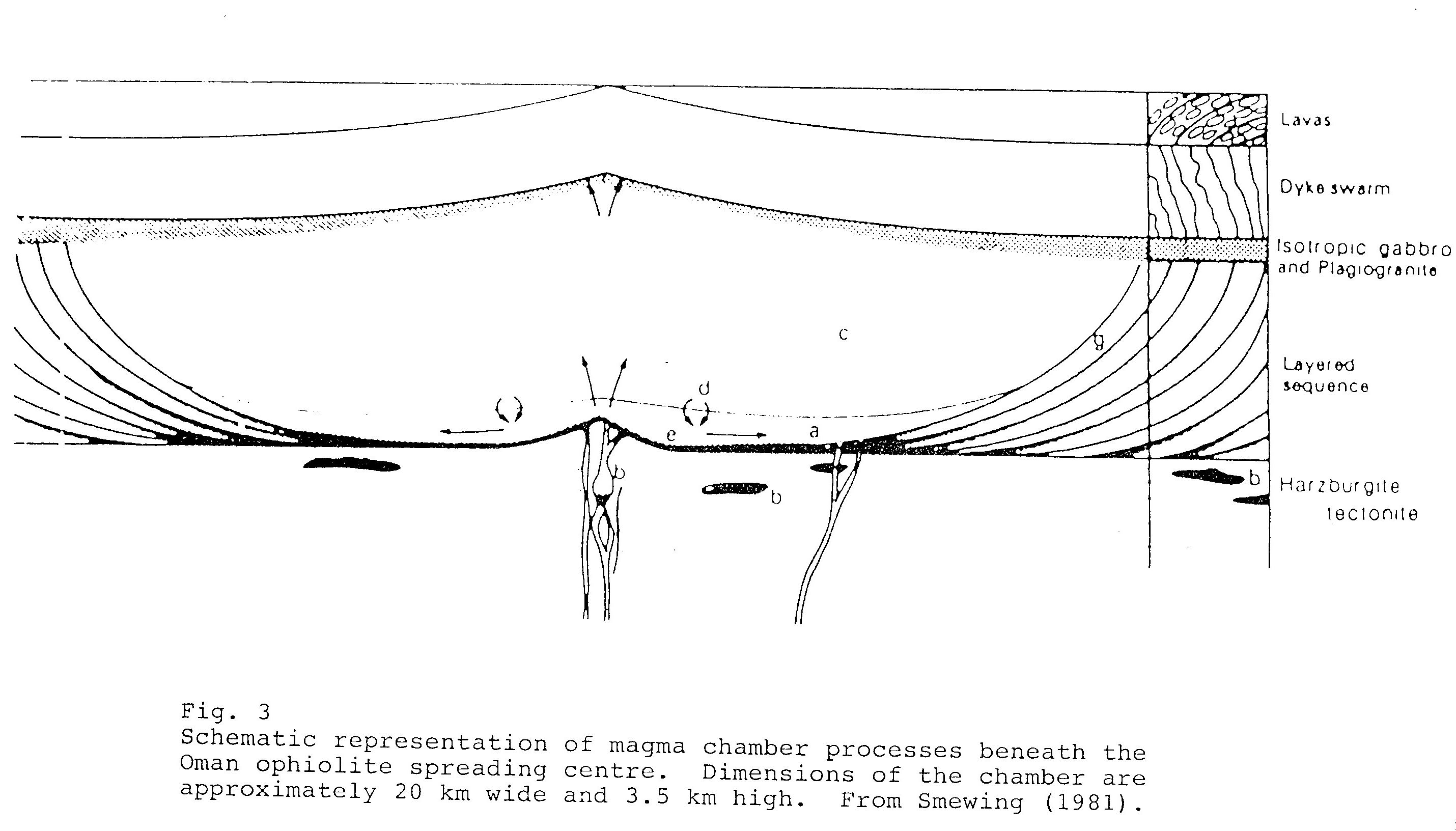
The Environment of Origin of the Hajjar Mountain OphiolitesIt is now accepted in a general sense that the ophiolite rocks of the Hajjar Mountains represent a piece of oceanic crust and upper mantle. However, a more arcane question addressed but not definitely answered by the symposium was whether these rocks represent the “classic” development of oceanic crust at a mid-ocean ridge (like the mid-Atlantic ridge or the major ridges of the East Pacific) (Fig. 3), or whether, instead, the Hajjar Mountain ophiolites represent something less typical, such as a “back-arc” spreading center.
Subsidiary zones of crustal stretching, mantle upwelling and creation of new crust may occur in oceanic regions above the downgoing lithospheric plate at a convection plate margin or subduction zone. Such back-arc spreading is known to be occurring at present in association with several major subduction zones in the Western Pacific. One of the earliest such subsidiary spreading centers to be identified was the Sea of Japan.
One argument for the formation and emplacement of major ophiolite complexes only in non-standard environments is their very rarity. At this point, however, the matter remains under scientific study. Discrimination between the various alternatives will depend upon detailed geochemical analysis, an improved reconstruction of the paleogeography and plate tectonic environment of the Gulf of Oman region in the late Cretaceous, and a better understanding of the chemical and tectonic processes that are occurring in similar environments at the present day.
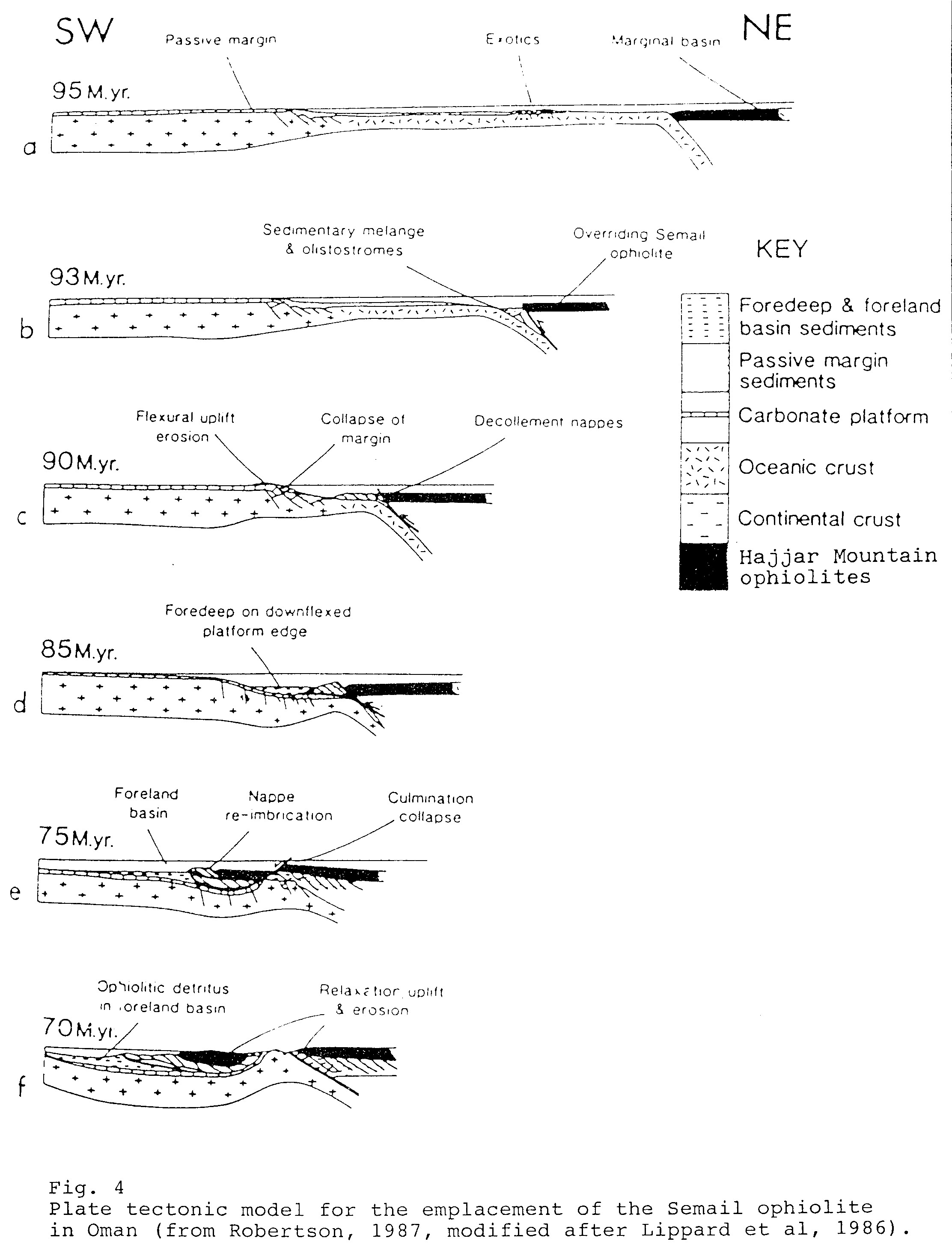
Emplacement of the Ophiolite SheetWhatever its precise environment of formation, it is generally agreed that the thick sheet of oceanic crust and upper mantle represented by the ophiolites of the Hajjar Mountains was emplaced in its present position by the process of obduction. Readers are assumed to be familiar with the concept of subduction, which, in the plate tectonic context, refers to the downward movement of one lithospheric plate under another at a convergent plate margin. This is usually associated with the formation of a deep ocean trench above the subduction zone, as in many places in the western Pacific Ocean.
Obduction occurs as a side effect of subduction and refers to the phenomenon whereby a piece of the upper portion of either the downgoing plate or the passive plate is sheared off and, instead of being shoved down and subducted, is instead thrust up and on top of the adjacent plate – either the passive plate or the remainder of the downgoing plate. The ophiolite sheet of the Hajjar Mountains is believed to have been emplaced along an east or northeast-dipping subduction zone and represents a piece of oceanic crust that was thrust up and over the continental crust of the Arabian platform on the western plate (which was being subducted) when that continental crust reached the subduction zone (Fig. 4).
It is consistent with current theory that subduction in that particular region would have ceased soon after the encounter with relatively light and buoyant continental crust. This does not meant that the overall convergent movement between plates would have ceased following an encounter with the Arabian continental platform, but the locus of subduction would have shifted to a more congenial environment. For example, a parallel subduction zone might have been established some distance away to the east.
In detail, however, the picture is undoubtedly at least somewhat more complicated than this generalized explanation, because the ophiolites of the Hajjar Mountains appear to represent a piece of oceanic crust that originally contained within it major lateral offsets like the offsets of the present day mid-Atlantic ridge, which are known as transform faults. These offsets are preserved today as the transverse structural alignments that mark many of the major Wadi systems that cross the Hajjar Mountains, like the Dibba Zone, Wadi Qowr, Wadi Hatta and Wadi Jizzi.
A more complex history is also hinted at by certain aspects of the metamorphic rocks that underlie the ophiolites in various places, and several much more elaborate reconstructions have been advanced by geologists studying the area. One invokes fundamental changes in plate motions occurring at the corner of the Arabian platform. Another involves partial overriding of a mid-ocean ridge at a subduction zone in the Gulf of Oman. Still another proposes the oblique movement of small fragments of plates along the edge of the Arabian platform. Each of these theories may prove to contain elements of truth, particularly with respect to the history of the Arabian continental margin prior to emplacement of the Hajjar Mountain ophiolites.
The Formation of the Hajjar MountainsThe date of formation of the ophiolite rocks themselves is believed to be in the range of 95- to 110-million years ago. Thrusting and emplacement of the ophiolites in their present position occurred during the Late Cretaceous (Late Cenomanian to Late Maastrichtian), or between 68- to 95-million years ago, as determined from stratigraphic and fossil evidence in related sedimentary rocks. Some folding and uplift of the ophiolites was contemporaneous with emplacement, and the wedge of sediments pushed ahead of the advancing ophiolite sheet was strongly folded and faulted along low angle thrust faults.
The region was subjected to further deformation and uplift in the mid-Tertiary (Oligocene and Miocene), during the period about 15- to 40-million years ago. That uplift was related to the original thrusting and emplacement of the ophiolites but was contemporaneous with an episode of major tectonic activity along the Alpine-Himalayan chain generally, including the Zagros Mountain belt in Iran. The Hajjar Mountains have remained a topographic high since that time, and erosion of the rising mountains has resulted in the deposition of more than 4 000 meters of relatively coarse detrital sediments in the neighboring Gulf of Oman.
In all, the various phenomena described here have conspired to create in the Hajjar Mountains a marvelous opportunity for geologists, hikers and nature lovers in the UAE and Oman to explore an environment that is both scenically and scientifically unique, and is greatly to be recommended.